|
History > 2011 > USA > Weather / Nature / Environment (III)
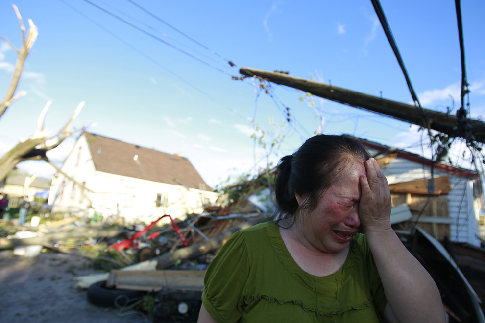
Chue Vang reacts after coming home to discover
that her home was damaged
after a tornado struck northern
Minneapolis May 22.
At least one person was killed
and at least 29 were injured in
the storm.
Jerry Holt/The Star Tribune/AP
Boston Globe > Big Picture
Deadly tornadoes strike again
May 23, 2011
http://www.boston.com/bigpicture/2011/05/deadly_tornados_strike_again.html
Joplin
Faces Sad Task of Clearing the Rubble
May 25,
2011
The New York Times
By A. G. SULZBERGER and RICHARD A. OPPEL
JOPLIN,
Mo. — As rescue workers continue to sift through the wreckage of this city piece
by piece, hoping to unearth survivors and victims of a lethal tornado, local
leaders have been wrestling with the difficult question of when to start
cleaning up the destroyed area.
They know that ultimately they must sweep away what the storm did not.
But so far the word bulldoze is one that they have been hesitant to use in news
conferences, as rescue and recovery efforts continue. But they acknowledge that
it is only a matter of time before the battered and blown-down houses, which
cover an area stretching more than a half-mile wide and six miles long, have to
be stripped to their foundations and hauled away.
Standing in a wreckage-strewn park across from a hospital that is now only a
concrete shell, the mayor pro tem, Melodee Colbert-Kean, said that officials
understood the need to be careful about how fast they moved forward. In addition
to the considerable logistical challenges, there are the emotional
considerations imbued in the splintered lumber, crushed brick and strewn
personal possessions — as well as the remains of the missing.
“To a lot of people, it’s just rubble,” she said. “But to a whole bunch more,
it’s lives.”
That rubble was once assembled neatly into more than 5,000 buildings stretching
through nearly a third of the city. Now it is where at least 125 people died,
the most in a single tornado since modern record-keeping began in the United
States in 1950. It is a rolling junkyard presided over by the jagged forms of
denuded trees. The mess revealed a prosthetic leg, a college thesis, a live
guinea pig, an empty wheelchair, a pocket watch, and a child’s doll.
Still, even residents of the hardest-hit area seemed to carry a gloomy
resignation about what was surely ahead. “What else can you do but bulldoze it?”
said Anna Kent, 54, as she wandered through rubble that once was a friend’s home
in search of missing items. “They ought to draw a perimeter around all of it and
take it all. What else can you do?”
After days exposed to the constant rain, these piles already smelled of mold.
Nails and other sharp objects tore through tires and shoes alike. Even so,
residents continued to stay in the damaged area, along with looters seeking both
precious and scrap metal, and gawkers who have slowed emergency vehicles by
creating traffic jams.
No new bodies or survivors were found Wednesday after the debris was searched a
third time, said Mark Rohr, the city manager. City officials said that local
leaders were already talking to the Army Corps of Engineers coming into the area
to clear it of the wreckage, though it remained unclear where such a massive
amount of material would go. Gov. Jay Nixon of Missouri said he waived certain
restrictions to speed the clean-up effort.
As they talk of tearing down they are also discussing efforts to rebuild the
area, with City Council members even discussing whether to change the zoning in
certain areas to better reflect the development of this mostly blue-collar city
of 49,000 in southwest Missouri. “We’re getting ready to have some lengthy City
Council meetings,” said Gary Shaw, a city councilor and former mayor.
For many residents, imagining a rebuilt Joplin was too much, too fast. Yes, they
said, Joplin will surely remake itself and people will build new homes and
businesses. But, at the moment, the thought of a reshaped city felt faraway,
said Kenny McGoyne, who was trying to find what was left of the bunk beds and
chairs beneath his crumbled business, Kenny’s Used Furniture Emporium. “In a
way, the place is already bulldozed,” he said. “I don’t know where we’ll go.”
Meanwhile, city officials were trying to find ways to manage access to the
destroyed area. Law enforcement officials were posted at major intersections to
keep people from entering, an effort that leaders said was aimed at preventing
looting and gawking. A curfew was also put into effect restricting access after
dark.
But a proposed permitting system was discarded just hours after it was put in
operation. The rules complicated efforts for family members and friends to
locate one another, since cellphone service was spotty, and going door to door
was one of the few ways to try to reconnect.
Even the families of the dead found access restricted. A makeshift morgue had
been set up in a metal warehouse outside town, but the authorities were not
allowing people inside to identify family members. An official said all
identifications would be done forensically to prevent misidentification — and
perhaps horror.
“A lot of them don’t understand there’s nothing to look at,” said Detective Sgt.
Craig Davis of the Jasper County Sheriff’s Department. Sergeant Davis said that
the tornado’s victims included his wife’s grandmother, but that even he had not
been allowed inside to identify her remains.
There were other signs that the trauma of the previous days was only just being
processed. Survivors living at a Red Cross shelter were forced to take refuge in
the basement of the college gymnasium late on Tuesday night when storms that had
already killed people in nearby Kansas, Oklahoma and Arkansas swept into Joplin
before moving on without further damage. The crowd bore the broken bones, black
eyes and bloody wounds sustained in the previous assault but also revealed some
psychological scars.
Some cried. Others stared blankly. One woman spoke of hearing in the pounding
wind outside a relentless freight train. “I have to walk fast,” said the woman,
Carole Yagel, who a nurse suspected of having post-traumatic stress disorder. “I
can’t walk slow. I have to get away from that sound. I’m afraid it will catch up
to me, and I’m afraid it will run me down. I’m always looking around, making
sure I’m O.K. But I can’t relax. My body is in ‘go’ mode.”
Don Wiese, 84, lost his house a year after he lost his wife. He tried to stay
there but was ordered out because it was not safe. But as the tornado siren
wailed he grumbled good naturedly.
“All Joplin needs is to get the rest of it destroyed,” he said. “I guess the
good Lord will take care of us. And if he don’t, we’ll be up there looking at
this mess.”
Monica Davey
contributed reporting.
Joplin Faces Sad Task of Clearing the Rubble, R,
25.5.2011,
http://www.nytimes.com/2011/05/26/us/26scene.html
Tornado death toll rises, no more survivors found
JOPLIN,
Mo | Wed May 25, 2011
9:18pm EDT
Reuters
By Elliott Blackburn
JOPLIN,
Mo (Reuters) - The death toll from a monster tornado that savaged Joplin,
Missouri, rose to 125 on Wednesday and tornadoes overnight in nearby states
caused at least 15 more deaths.
Three days after the deadliest single tornado in the United States in 64 years,
rescue teams with dogs sifted through rubble in Joplin without finding anyone
alive on Wednesday.
Authorities said the operation was still a search and rescue, but hope of
finding more people alive was fading.
The number of people injured by the massive tornado was revised up to more than
900, according to local authorities, from 823 earlier in the day.
Officials were no longer saying how many people are missing because they believe
the figure of 1,500 missing mentioned earlier in the week was inflated by double
counting or people simply being out of town.
Some families continued a desperate search for missing loved ones amid the ruins
of homes and businesses.
Fifteen-month-old Skyular Logsdon, whose blue teddy bear, red t-shirt and pants
were found wrapped around a telephone pole after the storm, remains missing, his
great grandmother told Reuters on Wednesday.
His injured parents were found and taken to a hospital after the tornado. But
the little boy has vanished.
"We're still hopeful," said Deb Cummins, great grandmother of the missing boy.
She said they have checked every possible hospital.
Another wave of tornadoes roared across the Midwest on Tuesday night, leaving
nine dead in Oklahoma, four fatalities in Arkansas and two in Kansas, officials
said.
In Newcastle, south of Oklahoma City, a storm blew the steeple off Jesus Alive
Church and carried it nearly 100 yards away, where it landed on the doorstep of
the longtime pastor's 86-year-old mother, Lovina Frizzell.
"I said 'Oh, my goodness, there's the steeple,'" Frizzell said as she swept her
front porch.
In Oklahoma alone, seven tornadoes tore across the state overnight, according to
the National Weather Service. The deadliest of those, which killed seven
persons, left a 75-mile path of destruction and lasted two hours.
Oklahoma authorities said a 22-year-old man died in hospital of injuries from
the storm, bringing the death toll in the state to nine.
Severe weather was continuing on Wednesday evening further east in Arkansas,
Tennessee, Mississippi and north into Illinois and Indiana, although winds so
far were not as threatening as on Tuesday night, according to meteorologists.
One funnel cloud struck Sedalia, Missouri, a town of 20,000 residents, on
Wednesday afternoon, damaging homes and businesses, overturning vehicles,
downing power lines and rupturing gas lines, emergency officials said.
Nervous Joplin residents were relieved after the threat of another tornado
heading for the city proved to be false overnight.
The Joplin tornado on Sunday was rated an EF-5, the highest possible on the
Enhanced Fujita scale of tornado power and intensity, with winds of at least 200
miles per hour.
EF-5 tornadoes are rare in the United States but already this year there have
been at least four. They are so destructive that experts said they can turn a
house into a missile.
Authorities in Joplin struggled to cope with the massive destruction. Some
14,000 customers in the city of 50,000 were still without power, water pressure
was low in many homes and a local cable and cellphone provider had only about 20
percent of its customers back up and running normally.
A system of permits to allow residents back to their damaged homes and prevent
looting was abandoned on Wednesday as long lines formed. Officials decided
instead to keep a strong police and National Guard presence while allowing
people free access to the miles of damaged neighborhoods.
This year has seen an unusually high number of tornadoes, with 1,168 as of May
22, compared to an average of about 671 by this time, according to Joshua
Wurman, president of the Center for Severe Weather Research in Boulder,
Colorado.
The U.S. is on pace to break the record for deaths from tornadoes this season,
the National Weather Service has said.
(Writing by
Carey Gillam and Greg McCune;
Additional reporting by Suzi Parker, Steve Olafson, and Kevin Murphy;
Editing by Peter Bohan)
Tornado death toll rises, no more survivors found, R,
25.5.2011,
http://www.reuters.com/article/2011/05/26/us-weather-tornadoes-midwest-idUSTRE74M08L20110526
Traumatized Joplin on edge as more storms rake Missouri
JOPLIN,
Mo | Wed May 25, 2011
6:28pm EDT
Reuters
By Elliott Blackburn
JOPLIN,
Mo (Reuters) - Traumatized residents kept a wary eye on storm clouds hanging on
Wednesday over the shredded remains of a large portion of this city.
Chainsaws and hammering could be heard in the neighborhoods surrounding the
hardest hit areas three days after a devastating tornado ripped through this
town of 50,000, killing 125 and injuring at least 823.
Residents took advantage of hours of sunlight to check their property and clear
debris. But as adrenaline and shock faded, residents near the damaged zone
described a fear of every rumbling in the wind.
Overnight, another wave of killer tornadoes roared across the Midwest, leaving
at least nine people dead in Oklahoma, four dead in Arkansas and two in Kansas,
officials said.
And on Wednesday, several fast-moving, strong storms raked Missouri, triggering
tornado warnings all across the state.
Jerry Harris rode out 200 miles-per-hour winds with his daughter in a closet in
his friend's homes, which was all that remained of the residence after the storm
passed.
The 42-year-old had years of training as a 911 dispatcher, he said, but felt
panic the next morning when he heard the rumbling of a heavy truck.
"It just scared me to death," Harris said.
Now, he is obsessed with having all his children around during storm warnings to
assure himself they are safe.
Rick Rice, a 57-year-old truck driver, said he would never again dismiss the
sirens he ignored Sunday. He had continued to remodel his bathroom as the
tornado approached. The storm left his home uninhabitable.
Now he spends his day monitoring the Internet for weather updates haunted by the
roaring of the wind.
"When I hear the noise, I can't get it out of my mind," Rice said.
Even residents who missed the worst of the storm changed habits. Greg Salzer, a
37-year-old social worker, watched the tornado from a safe distance. He and his
wife restocked their storm shelter the next day with shoes, important papers and
dog leashes.
"We spent Monday going through the storm shelter cleaning," he said.
On Wednesday, he was helping his uncle, 66-year-old Frederick Dalton, clean
debris not far from a ruined hospital.
Dalton said he had walked for blocks after the storm to find his wife safe at a
destroyed church.
The Joplin tornado on Sunday was rated an EF-5, the highest possible on the
Enhanced Fujita scale of tornado power and intensity, with winds of at least 200
miles per hour.
(Reporting
by James B. Kelleher)
Traumatized Joplin on edge as more storms rake Missouri,
R, 25.5.2011,
http://www.reuters.com/article/2011/05/25/us-weather-tornadoes-trauma-idUSTRE74O89520110525
Tornadoes death toll rises, more storms forecast
JOPLIN,
Mo | Wed May 25, 2011
4:42pm EDT
Reuters
By Elliott Blackburn
JOPLIN,
Mo (Reuters) - The death toll from a monster tornado that savaged Joplin,
Missouri, rose to 125 on Wednesday and tornadoes overnight in nearby states
caused at least 14 more deaths.
Bulldozers pushed through rubble in Joplin and teams searched through the night
over a six-mile-long path of destruction looking for survivors but found no one
alive in the rubble, authorities said.
At least 823 people were injured by the tornado that hit on Sunday at dinner
time, and an estimated 1,500 remain missing.
Another wave of tornadoes roared across the Midwest overnight, leaving eight
dead in Oklahoma, four fatalities in Arkansas and two in Kansas, officials said.
In Newcastle, south of Oklahoma City, a storm blew the steeple off Jesus Alive
Church and flung it nearly 100 yards away, where it landed on the doorstep of
the longtime pastor's 86-year-old mother, Lovina Frizzell.
"I said 'Oh, my goodness, there's the steeple,'" Frizzell told Reuters on
Tuesday evening as she stood on her front porch sweeping. "Yes, it's quite a
mess."
The latest nasty storm was moving east, putting Arkansas, northern Mississippi,
southern Illinois and Indiana at the highest risk for devastating tornadoes on
Wednesday, according to AccuWeather.com.
A line of storms and tornado activity moved across Kansas City and into western
Missouri on Wednesday afternoon, dipping in and out of rain clouds to wreak
havoc.
One funnel cloud struck Sedalia, Missouri, population 20,000, on Wednesday
afternoon, damaging homes and businesses, overturning vehicles, downing power
lines and rupturing gas lines, Pettis County Sheriff Kevin Bond told local
media. Search teams were rushing to tally the damage and aid the injured, he
said.
The storms on Wednesday could hit Joplin again although the weather was better
during the afternoon.
The Joplin tornado on Sunday was rated an EF-5, the highest possible on the
Enhanced Fujita scale of tornado power and intensity, with winds of at least 200
miles per hour.
EF-5 tornadoes are rare in the United States but already this year there have
been at least four. They are so destructive that experts said they can turn a
house into a missile.
Authorities in Joplin established checkpoints and issued permits to allow
homeowners to return to demolished sites and try to recover valuables.
So far 823 people had been treated for storm-related injuries, both in area
hospitals and in a temporary medical center set up in the town's concert hall,
which used equipment salvaged from the town's heavily-damaged main hospital.
In Arkansas, the National Weather Service reported a tornado flattened Denning,
a town of about 200 people.
Oklahoma Governor Mary Fallin and Arkansas Governor Mike Beebe were surveying
destruction in their states on Wednesday.
The storms also extended to North Texas, where tree limbs and other debris
littered Dallas-area roads. A Dallas man was found dead outside his apartment,
apparently after being electrocuted from downed power lines, Jason Evans, a
spokesman for the Dallas Fire Department, said on Wednesday.
About 10,000 people spent the night at Dallas/Fort Worth International Airport,
where golfball-size hail was reported, according to airport spokeswoman Sarah
McDaniel.
Two-hundred flights were canceled Tuesday night and another 100 on Wednesday,
McDaniel said. In addition, 61 flights scheduled to land at the airport were
diverted elsewhere. There were no injuries at the airport, she said.
(Writing by
Carey Gillam and Corrie MacLaggan; Additional reporting by Suzi Parker, Steve
Olafson, and Jim Forsyth; Editing by Greg McCune)
Tornadoes death toll rises, more storms forecast, R,
25.5.2011,
http://www.reuters.com/article/2011/05/25/us-weather-tornadoes-midwest-idUSTRE74M08L20110525
Joplin
tornado deaths up to 122, eighth deadliest on record
JOPLIN,
Mo | Tue May 24, 2011
7:48pm EDT
Reuters
JOPLIN,
Mo (Reuters) - A monster tornado that ripped through the small southwest
Missouri city of Joplin on Sunday killed at least 122 people and injured around
750. authorities said on Tuesday
The revised death toll was up from 118 fatalities given earlier on Tuesday, and
makes the giant twister the eighth deadliest in U.S. history, according to
officials speaking at a news conference.
Authorities also said the Joplin tornado was upgraded to an EF-5, or the highest
rating possible on the Enhanced Fujita scale of tornado power and intensity. The
Joplin tornado had previously been rated as an EF-4.
EF-5 tornadoes are rare in the United States but already this year there have
been at least four -- two in Mississippi, one in Alabama last month, and Joplin.
They are so destructive that experts said they can turn a house into an aerial
missile. Winds during the Joplin tornado were estimated at up to 200 miles per
hour.
The Joplin tornado damaged an estimated 8,000 structures in the city of about
50,000, authorities said.
(Reporting
by Megan Gates; Writing by Greg McCune; Editing by Jerry Norton)
Joplin tornado deaths up to 122, eighth deadliest on
record, R, 24.8.2011,
http://www.reuters.com/article/2011/05/24/us-usa-weather-tornadoes-idUSTRE74M08L20110524
Tornadoes touch down in Oklahoma, more expected
OKLAHOMA
CITY | Tue May 24, 2011
6:46pm EDT
Reuters
By Steve Olafson
OKLAHOMA
CITY, May 24 (Reuters) - Several tornadoes touched down in Oklahoma on Tuesday
afternoon, the largest one striking El Reno, west of Oklahoma City, and
continuing to the northeast, the National Weather Service said.
The tornado caused "extensive damage" in El Reno, a town of about 15,000 people,
said Rick Smith, a meteorologist with the National Weather Service in Norman.
"There are numerous trucks and cars overturned along Interstate 40," he said.
"It was a large tornado visually," Smith said. It was not clear what the
tornado's maximum winds were.
Additional supercell thunderstorms are developing southwest of Oklahoma City
that could spawn more tornadoes, Smith said. Supercell thunderstorms are
characterized by the presence of a deep, continuously-rotating updraft.
The state had been bracing all day for violent weather as the National Weather
Service reported conditions were ripe for tornadoes.
The new round of tornadoes began two days after a monster twister ripped through
the heart of Joplin, Missouri, killing at least 118 people. It was the deadliest
single tornado in the United States in some 64 years.
(Editing by
Corrie MacLaggan, Greg McCune and Paul Simao)
Tornadoes touch down in Oklahoma, more expected, R,
24.5.2011,
http://www.reuters.com/article/2011/05/24/usa-weather-tornadoes-midwest-idUSN2428225320110524
Searches Restart in Deadliest U.S. Tornado in 60 Years
May 24,
2011
The New York Times
By BRIAN STELTER and A.G. SULZBERGER
JOPLIN,
Mo. — The sun shone for the first time in days on this battered city Tuesday,
lifting spirits even as rescue workers performed the grim task of searching for
survivors and victims in buildings leveled by the United States’ deadliest
tornado in more than 60 years. At least 117 people have died.
On Tuesday morning, as search teams with dogs took advantage of a break in
windy, rainy weather to comb the wreckage that includes as many as 30 percent of
Joplin’s buildings, the death toll is expected to rise.
More bad weather may be on the way because of a weather system moving east
across the Rockies that will mix with moist air moving north from the Gulf of
Mexico.
“We are expecting some violent storms to develop across Kansas and Oklahoma
today bringing rain, hail and the risk of tornadoes that could move into the
Joplin area this evening,” said Doug Cramer, a meteorologist with the National
Weather Service. “This is a very good set up for very big tornadoes.”
The National Weather Service said the tornado that struck the city Sunday
evening had reached wind speeds of up to 198 miles per hour.
On Tuesday morning, American flags flew outside many houses, including those
that had been destroyed. About one-third of the most heavily damaged sections of
the city were cordoned off by the authorities on Tuesday as rescue teams with
dogs combed the rubble. Houses that had been searched had been marked with an
“X.” The authorities said they planned to complete a second sweep through the
city on Tuesday, looking into every structure that had been damaged — at least
2,000.
On Monday, crews pulled seven people out of buildings that had collapsed,
officials said.
“We’re hoping to find more folks, that’s why we’re doing these searches,” said
Keith Stammer, the Jasper County emergency management director.
On Tuesday morning, President Obama, who is on a state trip in Europe, said the
devastation in Joplin “is comparable and may end up exceeding the devastation
that we saw in Tuscaloosa, Ala., just a few weeks ago.” Mr. Obama said he would
travel to Joplin on Sunday to survey the tornado damage. He is scheduled to
return from Europe on Saturday.
Around midnight, the rain that had hampered rescue and cleanup operations all
day Monday finally let up, somewhat easing fears that at rescue workers and
victims would suffer from hypothermia overnight. At the corner of Main and 20th
Streets in Joplin, where a police checkpoint had been established, a small group
of nurses and medics staffed a first-aid station overnight, but had few
survivors to help. The makeshift station, set up outside a Walgreens drug store,
was lit up by generator lights and candles because power was still out in the
neighborhood.
“We know there’s people out there that need help, and all we can do is hope they
can get to us,” said Luci Tarter, a registered nurse.
Ms. Tarter, her husband, Jay, and the other volunteers had not given up hope
that people would be found alive.
“We’re hoping there are people that are still in basements that can’t get out,
who only have minor injuries,” said Jason Mangan, who worked at St. John’s
Regional Medical Center, which was badly damaged on Sunday evening.
Other employees of St. John’s said, half-jokingly, that they were now looking
for new jobs. There is certainly plenty for them to do.
“We’re a tenth of the way into the recovery,” said Andy Sutton, a full-time
ranch manager and a part-time medic from Nowata, Okla., who drove to Joplin
Monday morning to try to help. Mr. Sutton said he and two friends had spent
Monday afternoon walking through demolished neighborhoods shouting, “Is there
anybody here?”
“In my opinion, anybody who would have been alive would have responded,” he
said.
Mr. Sutton and roughly two dozen other people camped out overnight across the
street from St. John’s, where a parking lot had been turned into a war-zone
trauma ward that conjured up comparisons to “M*A*S*H.”
Volunteers first set up a warming tent to treat hypothermia, though it turned
out not to be needed; then they set up a second tent in anticipation of
survivors with injuries. To secure the tents, volunteers recycled metal from
collapsed doctors’ offices nearby.
As the first tent was nailed down, in walked Chris Faubion, a security officer
for St. John’s. “Somebody said they needed scrubs?” He handed over two bags’
worth. Mr. Faubion and others were salvaging all manner of supplies from the
hospital, even beds and pillows and oxygen tanks.
The supplies were shielded from the rain under biohazard decontamination tents
that someone found amid the chaotic scene Sunday night.
John Henkle, an owner of Henkle’s Ace Hardware in Joplin, was among those
helping to construct the tents, not knowing whether the facilities would be
needed in the morning. As he engaged in this city’s now-standard greeting — “Are
you O.K.?” — he tried to make light of the ordeal.
“I have a doctor’s appointment tomorrow 200 yards from here,” he said. Almost
nothing within 200 yards had been untouched by the tornado.
“I think my appointment’s canceled,” he said.
Timothy
Williams contributed reporting from New York.
Searches Restart in Deadliest U.S. Tornado in 60 Years,
NYT, 24.5.2011,
http://www.nytimes.com/2011/05/25/us/25tornado.html
Powerful tornadoes kill at least 31 in Midwest
KANSAS
CITY | Mon May 23, 2011
1:26am EDT
Reuters
By Kevin Murphy
KANSAS
CITY (Reuters) - Tornadoes tore through parts of the U.S. Midwest on Sunday,
killing at least 30 people in the Missouri town of Joplin and causing one death
in Minneapolis as well as causing extensive property damage.
The Joplin deaths came from a powerful tornado that plowed through the
southwestern Missouri town of some 50,000 people late on Sunday afternoon.
"At this point we know we are up into the 30 range," Newton County Coroner Mark
Bridges told Reuters by telephone when asked about the deaths.
"We have heard up into the over-100 (range), but ... I don't think anyone has a
good count right now," he said of the casualties. He also said that 11 bodies
had been recovered from just one location.
The storms continued to build on the violent weather this spring in the United
States, which saw more than 330 deaths last month as tornadoes swept seven
states. That included 238 deaths in Alabama alone on April 27 as twisters
battered Tuscaloosa and other towns.
Missouri Governor Jay Nixon earlier on Sunday said on CNN that an unknown number
of people had perished, saying, "We don't have any numbers, but we have had
confirmation that there have been deaths."
Nixon declared a state of emergency and announced he was ordering Missouri
National Guard troops be deployed to help state troopers and other agencies
respond to storms that he said "have caused extensive damage across Missouri."
Whole neighborhoods as well as a hospital in Joplin were badly damaged,
according to authorities and local television footage.
"It's done quite a bit of damage," a police officer in Joplin told Reuters by
telephone. "It hit quite a few parts of town."
Missouri State Highway Patrol dispatcher Charles Bradley said the extent of the
damage is still unknown as a variety of state and local agencies send help to
the area.
"There is a hospital that was majorly damaged," Bradley said of Joplin's damage.
"It's kind of like Tuscaloosa again."
BUILDINGS
LEVELED
Denise Bayless, 57, who lives north of the city, told Reuters by telephone that
many buildings on Main Street were leveled and the town's only high school was
burning.
She and her husband were at church when their adult son called to say the
tornado was hitting his house, and the couple got in their car to drive to his
aid.
"We just had to weave in and out of debris. Power lines were down everywhere,
and you could smell gas. It was scary," she said.
Carla Tabares and her husband Tony were in the Outback Steakhouse in Joplin when
the tornado hit. They had just run through raindrops into the restaurant and sat
down to order when a waitress told them a tornado was headed their way.
"It was really awful, really scary," said Tabares.
She and her husband squeezed into the restaurant's cooler with several families
and children in the dark, hearing the howling of the winds outside. When they
emerged, their building was largely unscathed but several other nearby
restaurants and businesses suffered severe damage.
"I'm just thankful we got out alive and I really feel sorry for the people who
didn't," said Tabares.
Another tornado ripped through the north end of Minneapolis and some suburbs on
Sunday, tearing roofs off dozens of homes and garages, killing one person and
injuring at least 30 others, authorities said.
The twister struck Sunday afternoon and plowed across a 3- to 5-mile area in a
northeasterly direction, Assistant City Fire Chief Cherie Penn told Reuters in a
telephone interview.
Storms knocked out electricity to about 22,000 homes and businesses in the area,
but power was restored to several thousand customers within hours, according to
Xcel Energy Inc spokeswoman Mary Sandok.
Tornadoes overnight on Saturday in northeast Kansas killed one person and
damaged some 200 structures. A state of emergency was declared for 16 counties,
state officials said.
(Reporting
by Kevin Murphy, Carey Gillam, David Bailey and Colleen Jenkins; Writing by
Steve Gorman; Editing by Jerry Norton and Peter Bohan)
Powerful tornadoes kill at least 31 in Midwest, R,
22.5.2011,
http://www.reuters.com/article/2011/05/23/us-usa-weather-tornadoes-idUSTRE74M08L20110523
Record
Snowpacks Could Threaten Western States
May 21,
2011
The New York Times
By KIRK JOHNSON and JESSE McKINLEY
STEAMBOAT
SPRINGS, Colo. — For all the attention on epic flooding in the Mississippi
Valley, a quiet threat has been growing here in the West where winter snows have
piled up on mountain ranges throughout the region.
Thanks to a blizzard-filled winter and an unusually cold and wet spring, more
than 90 measuring sites from Montana to New Mexico and California to Colorado
have record snowpack totals on the ground for late May, according to a federal
report released last week.
Those giant and spectacularly beautiful snowpacks will now melt under the
hotter, sunnier skies of June — mildly if weather conditions are just right,
wildly and perhaps catastrophically if they are not.
Fear of a sudden thaw, releasing millions of gallons of water through river
channels and narrow canyons, has disaster experts on edge.
“All we can do is watch and wait,” said Bob Struble, the director of emergency
management for Routt County in north-central Colorado. The county’s largest
community, Steamboat Springs, sits about 30 miles from the headwaters of the
Yampa River, a major tributary of the Colorado River that has 17 feet of snow or
more in parts of its watershed.
“This could be a year to remember,” Mr. Struble added in a recent interview in
his office as snow fell again on the high country.
No matter what happens, the snows of 2011, especially their persistence into
late spring, have already made the record books.
But the West has also changed significantly since 1983, when super-snows last
produced widespread flooding. From the foothills west of Denver to the scenic,
narrow canyons of northern Utah, flood plains that were once wide-open spaces
have been built up.
Many communities have improved their defenses, for example, by fortifying
riverbanks to keep streams in place, but those antiflood bulwarks have for the
most part not been tested by nature’s worst hits.
And in sharp contrast to the floods on the Mississippi River — one mighty
waterway, going where it will — the Western story is fragmented, with anxiety
dispersed across dozens, perhaps even hundreds, of large and small waterways
that could surge individually, collectively or not at all.
¶ In California, officials staged three days of flood training last week,
running disaster scenarios and practicing the grunt work of filling sandbags and
draping and tying down tarp. The state’s aging levee system has long been a
source of concern, with fears of large-scale failures that could leave
Sacramento, the state capital, vulnerable to a Hurricane Katrina-scale flood.
The anxieties are amplified this year by the deep snows in the Sierra Nevada,
where some ski spots around Lake Tahoe saw more than 60 feet this season.
¶ At Flaming Gorge Reservoir on the Green River in Utah, federal managers have
begun spilling water downstream in preparation for the rising waters; the
reservoir has 700,000 acre-feet of available space, but will have an expected
inflow of 1.4 million acre-feet more through July, federal officials said.
¶ In the Wasatch Mountains outside Salt Lake City, where Alta Ski Resort still
has about 200 inches of snow, cool temperatures have kept snowpacks from
crossing what hydrologists call the isothermal barrier — 32 degrees Fahrenheit
throughout the snowmass — which allows gradual melting from the bottom. Three
more feet of snow piled on just last week.
¶ In sparsely populated Wyoming, emergency officials are worried about tiny
communities that in many cases are far from help if rivers surge; almost every
county is in a potential snow-melt flood zone, and relatively few residents have
flood insurance.
¶ Here in Routt County, the terrain itself has changed, with thousands of acres
of dead lodgepole pine trees on high mountain slopes. The trees were killed by
an infestation of beetles in recent years and no longer hold the soil as they
once did, raising erosion concerns.
Hydrologists, meanwhile, are cheering what they say will be a huge increase in
water reservoir storage for tens of millions of people across the West. Lake
Mead and Lake Powell, two huge dammed reservoirs on the Colorado River battered
in recent years by drought, are projected to get 1.5 trillion gallons of new
water between them from the mammoth melt.
But from Sacramento to Baggs, Wyo., a town of about 600 people on the Little
Snake River, 150 miles west of Cheyenne, looking upslope in May and seeing lots
of white is scary.
Late spring is a volatile time in the mountains, when freezing temperatures can
turn overnight to heat waves and thunderstorms. And every day that the snows do
not go gently down the stream raises the possibility of melting into late June
and even July, when sudden mountain downpours can set off flash floods,
dangerous even without a freight of snow behind them.
Floods kill more Americans than lightning, tornados or hurricanes in an average
year, according to federal figures. And flash floods, usually associated with
summer downpours, like the one that killed more than 140 people in Big Thompson
Canyon in Colorado in 1976, can come as if from nowhere.
“It just takes one really sunny hot spell to get things running,” said Arthur
Hinojosa, the chief of the Hydrology and Flood Operations Office with the
California Department of Water Resources. “And that’s where our concern lies.”
Mr. Hinojosa added that the state had ample storage and diversion facilities to
the north of Sacramento, where the city’s namesake river runs, but that that is
less true of the San Joaquin River, which wends through the state’s
agriculturally rich Central Valley to the south.
Several major tributaries, including the Merced and Tuolumne Rivers, spill into
the San Joaquin, which runs north into the Sacramento-San Joaquin Delta, a
collection of low-lying islands and waterways that serve as farmland, a
recreation zone and the pumping location for water-hungry farms and residents to
the south.
On Wednesday, as part of the California flood training, several dozen disaster
officials and workers descended on Twitchell Island, a 3,500-acre delta
depression, where land can sit up to 20 feet below sea level. Scores of homes
also sit below levees, which hold back water and create marinas, adding the
surreal scene of sailboats bobbing above the roofs of houses and farmland.
Some disaster officials say it is the clock that is driving them crazy — every
day of postponed melt being cause for a sigh of relief and heightened anxiety
from the looming June warmth.
But lingering snows are proving a bonus for others. Arapahoe Basin and Aspen ski
areas in Colorado, for example, plan to keep their chairlifts running on some
weekends, in Arapahoe’s case, through at least June 19.
Kirk Johnson
reported from Steamboat Springs, Colo.,
and Jesse McKinley from Twitchell Island, Calif.
Record Snowpacks Could Threaten Western States, NYT,
21.5.2011,
http://www.nytimes.com/2011/05/22/us/22snow.html
Flooding threat along Mississippi River
is a
test of man vs. nature
Sunday,
May 22
2:24 AM
The Washington Post
By Joel Achenbach
The snakes are out. And the bears. The gators. The jumbo rodents known as
nutria. The feral hogs. They seek higher ground as the floodwaters advance, and
that can mean the top of a levee or in someone’s back yard. Herds of deer have
clumped on tiny islands in an ancient swamp that is becoming a lake.
The humans are scrambling, too. They’ve filled a million sandbags. The flood
fighters deploy barriers known as tiger dams, HESCO baskets, aqua tubes and
sheet pile. The hospitals have stockpiled antivenin in anticipation of a surge
in snakebites. Officials the other day shot a 10-foot gator on a levee near New
Orleans.
Engineers on Saturday were tracking roughly 250 seepage points along the levees
that line the Mississippi and Atchafalaya rivers. The levees sit on fine sand
that lets the river water escape like a convict tunneling out of prison. The
water can pop up a mile away. Left to its own devices, one of these sand boils
(where water erupts as if from spring) can undermine a levee and lead to a
crevasse, a full levee failure — and disaster.
There’s a war underway, fought across the Mississippi’s 35,000-square-mile
alluvial plain. This is the toughest test since 1973 of the Army Corps of
Engineers’ flood-control system along the Mississippi, which drains 41 percent
of the land in the lower 48, and is now swollen by snowmelt from the Rockies and
rainwater from the soggy Ohio River Valley.
For the moment, engineers seem to have the upper hand. They are not claiming
victory, however. This is not simply a big flood but also a long flood, one that
will last well into June. A flood exists in four dimensions, including time —
because a long-duration flood can be more problematic than one that crests and
recedes quickly.
“Everything that is part of our toolbox is in use,” reports Col. Ed Fleming, New
Orleans district commander for the Corps. “There’s no doubt there is going to be
a long crest.”
His colleague Mike Stack, chief of emergency management for the Corps at New
Orleans, says, “The system is under tremendous stress, and it’s going to be that
way for a while.”
Stack added: “It’s performing as it’s designed.”
‘Dealing
with earth’
But as with any complex system of engineering, there are weak points, question
marks, vulnerabilities. Powerful forces are being checked with levees made of
clay.
Four barges carrying Midwest grain broke loose Friday in Baton Rouge, and two of
them sank. That shut down the river for five miles and kept officials fretting
well into Saturday as they worried that one of the barges might plow into a
levee and create a breach.
“That system is designed to handle the river and the pressure of the river. It
is absolutely not designed to handle a barge hitting it,” Steve Wilson,
president of the Pontchartrain Levee District, said Saturday.
“We’re not dealing with digital technology. We’re dealing with earth,” said
Joseph Suhayda, a retired Louisiana State University coastal hydrologist. “This
goes back to the beginning of civilization. It’s available, it’s cheap, but it’s
not very good material.”
He went on: “These seepages and sand boils are reflections of the fact that
there are some continued deficiencies in the system. This is not a robust
system. It’s not concrete.”
The Army Corps has long prepared for a hypothetical inundation known as the
Design Flood. This flood pretty much fits that template. The flow, measured in
cubic feet per second, isn’t quite at Design Flood levels, but there are places
where the river gauges have measured record-high water, busting the old mark by
three feet in some spots.
For years, the smart money has bet that, in the protracted wrestling match on
the Mississippi between man and nature, nature will ultimately come out on top.
The decision, going back to the 19th century, to imprison a naturally meandering
river between levees — parallel Great Walls of China, to use the common analogy
— has the inevitable effect of raising the water level downstream. Even at
normal stages, the river stands up “like a vein on the back of a hand,” as John
McPhee wrote in his 1989 best-selling book “The Control of Nature.”
Staying
vigilant
Levee failures can be killers. National Guards now walk the levees day and
night. They want to pounce on small problems before they become big problems.
A week ago, an enormous sand boil appeared just north of the Louisiana border,
in Arkansas. It measured more than 120 feet across. Soon surrounded by sandbags,
it became an instant swimming pool. The downward pressure of the pooled water
counterbalanced the pressure from the nearby river.
“I’m feeling vigilant. Literally saying prayers every day,” said Garret Graves,
chairman of the Louisiana Coastal Protection and Restoration Authority. “The
potential disaster here is real, and we’re doing everything we can to make this
go down in history as simply a record-high-water event rather than a record
disaster.”
The system is designed to limit the river stages at Baton Rouge and New Orleans
during a major flood. The solution is diversion. First, the Corps opened the
Bonnet Carre spillway north of New Orleans, dumping a portion of the river flow
into Lake Pontchartrain. Then the Corps opened the Morganza spillway, north of
Baton Rouge. That relief valve, completed in 1954, has been opened only once
before, during the 1973 flood.
The moves do not come without a cost. Fresh water is surging into normally
brackish Lake Pontchartrain, with potentially devastating effects on the marine
life there. And to the west, the Atchafalaya River basin is slowly filling with
water diverted at Morganza. Residents have evacuated, some unhappy to have their
lives disrupted to spare the big cities and industries to the east.
Day by day the water surges Niagara-like through the Morganza spillway and
advances through the kingdom of crawfish.
Perhaps the trickiest part is ahead: Once the water hits Morgan City, it will be
pinched by levees and floodwalls and will begin to “stack up.” As the water
rises in the floodplain, it will find ways to spill into adjacent areas in a
process known as backflooding.
For example, Bayou Chene is a major concern for public officials and residents
in low-lying communities. Floodwater will sluice past the high walls of Morgan
City on its way to the gulf, and then take a sharp left, into Bayou Chene, and
attempt to flow back north, into a lake that could swamp Morgan City from the
rear.
To stop that from happening, engineers have sunk a barge, 480 feet long, in the
mouth of Bayou Chene. They’ve rammed sheets of steel in front and back, and
flanked it with giant boulders. The top of the barge juts above the water line.
It’s an emergency dam, a fat finger in the dike.
“This is not something that somebody drew up on the back of an envelope.
Engineers thought this through,” Fleming said.
Environmental impact
The chemistry of that floodwater is also raising concerns. Anna Hrybyk, program
manager for an environment organization called the Louisiana Bucket Brigade,
said the floodwaters could inundate hundreds of abandoned petrochemical waste
pits.
“Some of these waste pits are like a New York City block long. They’re huge. And
they’re not covered. And they’re not lined. Imagine 25 feet of floodwaters
running over these things.”
The ultimate fear for the Army Corps is that the Mississippi’s primary
distributary, the Atchafalaya, could capture the majority of the river flow,
which could devastate the shipping and petrochemical industries on the lower
Mississippi. Preventing the Atchafalaya from doing that has been the job of an
elaborate apparatus called the Old River Control Structure, which is not far
upriver from the Morganza spillway. During the 1973 flood, that structure was
badly undermined by churning water. It was to avoid a repeat of that incident
that the Corps opened the spillway gradually.
Even if the system passes this test, there’s a bigger flood out there, somewhere
in the future. Every new parking lot, channelized stream or other drainage
improvement in the watershed upriver translates to faster runoff and higher
water down in the delta. And climate scientists will point out that a hotter
planet can carry more moisture in the atmosphere, leading to intensified
deluges.
Graves said the system may be working now, but it’s still not ideal.
“It’s a good system. Is it a great system? No. We need more options, ultimately.
We need more relief valves. This thing is literally being tested to its rim.
It’s not a comfortable feeling,” he said.
After a beat, he added: “Is that the understatement of the year?”
Flooding threat along Mississippi River is a test of man
vs. nature, WP, 22.5.2011,
http://www.washingtonpost.com/national/flooding-threat-along-mississippi-is-a-test-of-man-vs-nature/2011/05/20/AFz1yh8G_story.html
Louisiana bayou towns brace for flooding impact
AMELIA,
Louisiana | Sun May 15, 2011
7:30pm EDT
Reuters
By Kathy Finn
AMELIA,
Louisiana (Reuters) - A day after Army engineers opened a key spillway to
relieve flooding along the Mississippi River, residents of small Louisiana towns
braced on Sunday for a surge of water that could leave thousands of homes and
farms under as much as 20 feet of water.
The U.S. Army Corps of Engineers on Saturday opened two of the 125 floodgates at
the Morganza Spillway 45 miles northwest of Baton Rouge, and opened two more on
Sunday.
Opening the floodgates -- a move last taken in 1973 -- will channel water away
from the Mississippi River and into the Atchafalaya River basin. That will take
the floodwaters toward homes, farms, a wildlife refuge and a small oil refinery
but avoid inundating New Orleans and Louisiana's capital, Baton Rouge.
In towns like Amelia, about 100 miles south of the spillway, crews worked around
the clock to build earthworks and reinforce levees ahead of a torrent of water
expected to reach the area on Monday or Tuesday.
"I hope they know what they are doing," said Hue Tran, watching the giant dump
trucks from the Quik General food store, a short distance from the intercoastal
waterway.
Weeks of heavy rains and runoff from an unusually snowy winter caused the
Mississippi River to rise, flooding 3 million acres (1.2 million hectares) of
farmland in Mississippi, Tennessee and Arkansas and evoking comparisons to
historic floods in 1927 and 1937.
Louisiana towns in the path of the floodway like Krotz Springs, Butte LaRose and
Morgan City are making similar plans for severe flooding that could last for
three weeks before the water works its way to the Gulf of Mexico.
In Krotz Springs, which will be among the first towns to feel the flood's
effects, Kathy Reed-Eason spent the weekend moving her parents' belongings out
of harm's way.
"My mom was crying," Reed-Eason said. "Mom said she'd go look at the river, and
get out of the house."
About 2,000 people were ordered to evacuate from St. Landry Parish, just south
of Krotz Springs.
FLOODWATERS COULD LINGER FOR WEEKS
About 2,500 people live in the spillway's flood path and 22,500 others, along
with 11,000 buildings could be affected by backwater flooding -- the water
pushed back into streams and tributaries that cannot flow normally into what
will be an overwhelmed Atchafalaya River.
Some 3,000 square miles (7,770 sq km) of land could be inundated in up to 20
feet of water for several weeks. When flows peak around May 22, the spillway
will carry about 125,000 cubic feet per second, about one quarter of its
capacity.
In Stephensville, a small town near Morgan City, Ronnie Wiggins and his
neighbors furiously filled sandbags to protect their houses.
Wiggins had few kind words to say about the spillway's opening.
"It's all about saving Baton Rouge and New Orleans while they flood people down
here," Wiggins said, pointing out that most people in his neighborhood did not
carry flood insurance.
"So I guess it's all about saving the rich and burying the poor?" he asked.
Some 18,000 acres of cropland could be flooded as waters rise, hitting their
crest in about a week and remaining high for several weeks.
Failing to open the spillway would have put New Orleans at risk of flooding
that, according to computer models, would eclipse that seen during Hurricane
Katrina in 2005. About 80 percent of the city was flooded by Katrina and 1,500
people were killed.
In addition to threatening densely populated areas, lower Mississippi flooding
was a risk for as many as eight refineries and at least one nuclear power plant
alongside the river.
The refineries make up about 12 percent of the nation's capacity for making
gasoline and other fuels.
The Corps said the gradual opening of the spillway's gates would prevent an
immediate rush of water. Alon USA Energy was working on Sunday to build a levee
around its 80,000 barrel-per-day refinery in Krotz Springs, which expects to be
surrounded by water within 14 days of the spillway opening.
Exxon Mobil's 504,500 barrel-per-day refinery in Baton Rouge, the nation's
second-largest, was not expected to cease operations but its Mississippi River
dock was shut due to high water, a plant spokesman said.
(Additional
reporting by Kristen Hays in Krotz Springs and Erwin Seba in Houston; Writing by
Chris Baltimore; Editing by Bill Trott and Peter Cooney)
Louisiana bayou towns brace for flooding impact, R,
15.5.2011,
http://www.reuters.com/article/2011/05/15/us-flooding-idUSTRE74462I20110515
Record
Water for a Mississippi River City
May 15,
2011
The New York Times
By CAMPBELL ROBERTSON
VICKSBURG, Miss. — Late Sunday morning, as the Mississippi River was rushing
faster and higher past this town than it has in 183 years of record-keeping,
Dontaye Buck was sitting perfectly still.
He was staring at a calm puddle of water in which his house sat. A man standing
beside Mr. Buck’s mailbox was casting a fishing line into a neighbor’s yard.
“It never came this far,” said Mr. Buck, a 21-year-old college student. “The
farthest it ever came was the backyard of that house back there.”
The city of Vicksburg sits safely on lofty bluffs, except where it does not. The
Kings neighborhood, where Mr. Buck lives in the north part of town, is one of
the places where it does not.
Sunday in Kings was, for the most part, as it is in any other neighborhood, full
of lawnmowers, barbecues and men standing around talking about nothing in
particular. The difference was the muddy lake that was slowly consuming the
neighborhood from the back.
Variances in elevation that would have gone unnoticed a few weeks ago now
separate those who are nervous but dry from those whose houses are submerged
nearly to the eaves. The water was not rising, residents said, so much as it was
spreading, quietly. And the river that had pushed the water here was churning
ferociously.
Around 10 a.m. on Sunday, according to officials from the Army Corps of
Engineers, the river broke the record elevation set here during the flood of
1927, rising to 56.3 feet, 13 feet above flood stage and 1.2 feet below the
predicted crest on Thursday. It was flowing by at a rate of nearly 17 million
gallons a second, which is the highest rate it is likely to reach in its entire
race down to the Gulf of Mexico.
Those numbers may be nerve-racking for those along its banks, but the weekend
also brought some relatively good news: the failure of a predicted rain storm to
appear has resulted in a lower estimated crest downriver at Natchez.
Furthermore, the Yazoo River, engorged with Mississippi backwater, had been
projected to overtop its levees at some point this weekend, flooding 285,000
acres of delta farmland and threatening some anxious country towns. But the
overtopping, designed into the system as a sort of relief valve, has not
happened yet.
If the Mississippi comes in a few inches lower than predicted as it passes
Vicksburg, the overtopping may not happen at all.
“It’s going to be really close,” said Robert Simrall, the chief of water control
for the Vicksburg district of the corps.
These yardsticks are more or less irrelevant for the residents of Kings. While
the river has been indifferent to income, folding over multimillion-dollar homes
and valuable farmland in the delta along with single-wide trailers in Kings, the
consequences for rich and poor vary considerably.
“Out of the whole community, I would say it’s probably three families with flood
insurance,” Mr. Buck said.
The worries here are as much about the water as what it will bring in the weeks
it sits here. Snakes, of course. Just about everyone in the neighborhood knows
someone who has recently seen an alligator, or killed one, or lost a dog to one.
More acute is the worry about who might come to their homes if they have to
evacuate, and what those people might do or take.
The traffic was slow along Washington Street here, as gawkers pulled off on the
increasingly narrow shoulder, emerging in Sunday clothes to take pictures of an
old brick church that itself was undergoing something of a full-immersion
baptism.
“This is ridiculous,” said Tawanna Bush, a 36-year-old waitress at a Cracker
Barrel restaurant, looking at the top third of her uncle’s house. “Is it a
sign?”
“Yeah, it’s a sign,” said Jackson Floyd, 49, offering the practical fatalism of
those who have known hard luck. “It’s a sign that it’s time to move and get
another house.”
Catrin
Einhorn contributed reporting.
Record Water for a Mississippi River City, NYT, 15.5.2011
http://www.nytimes.com/2011/05/16/us/16flood.html
Louisiana braces as flood spillway opens
MORGANZA,
Louisiana | Sat May 14, 2011
9:52pm EDT
Reuters
By Kathy Finn
MORGANZA,
Louisiana (Reuters) - Army engineers on Saturday opened a key spillway to allow
the swollen Mississippi River to flood thousands of homes and crops but spare
New Orleans and Louisiana's capital Baton Rouge.
The Army Corps of Engineers opened one of the 125 floodgates at the Morganza
Spillway 45 miles northwest of Baton Rouge shortly after 3 p.m. CDT, sending a
flume of water onto nearby fields.
The move, last taken in 1973, will channel floodwaters toward homes, farms, a
wildlife refuge and a small oil refinery in the Atchafalaya River basin to avoid
inundating Louisiana's two largest cities.
Weeks of heavy rains and runoff from an unusually snowy winter caused the
Mississippi River to rise, flooding 3 million acres of farmland in Mississippi,
Tennessee and Arkansas and evoking comparisons to historic floods in 1927 and
1937.
It could take three weeks for the enormous flow of water to pass through a
system of levees and spillways to the Gulf of Mexico about 100 miles to the
south, said Major General Michael Walsh, president of the Mississippi River
Commission.
"It's putting tremendous pressure on the entire system as we try to work this
amount of water through the Mississippi River tributaries," Walsh told reporters
before the floodgates opened.
Some 3,000 square miles of land could be inundated in up to 20 feet of water for
several weeks. When flows peak around May 22, the spillway will carry about
125,000 cubic feet per second, about one quarter of its capacity.
About 2,500 people live in the spillway's flood path, and 22,500 others, along
with 11,000 buildings could be affected by backwater flooding -- the water
pushed back into streams and tributaries that cannot flow normally into what
will be an overwhelmed Atchafalaya River.
Some 18,000 acres of cropland could be flooded as waters rise, hitting their
crest in about a week and remaining high for several weeks before subsiding.
"The land's going to wash away, but that's life," said Hurlin Dupre, who
represents Krotz Springs on the St. Landry Parish Council. "The worst of it is
we are in a drought and we can't use none of that water."
PROTECTING
NEW ORLEANS
Failing to open the spillway would have put New Orleans at risk of flooding
that, according to computer models, would eclipse that seen during Hurricane
Katrina in 2005, when 80 percent of the city was flooded. About 1,500 people
died in the disaster.
In addition to threatening densely populated areas, lower Mississippi flooding
threatened as many as eight refineries and at least one nuclear power plant
alongside the river.
The refineries make up about 12 percent of the nation's capacity for making
gasoline and other fuels.
In the Atchafalaya River basin, authorities went door to door to begin
evacuations in small towns and parishes in the path of the water, which could
take weeks to reach the Gulf of Mexico.
Louisiana Governor Bobby Jindal said on Friday the state had plans with the
American Red Cross to provide shelters for evacuees.
"I'm very scared," said Heidi Fangue, a Morganza resident. "I have my bags
packed and ready to go."
Fangue, who was selling T-shirts that read "Morganza Spillway 2011 -- Gates
finally opened," said she would depart in her mother's camper once floodwaters
began to creep over the nearby levee.
In Morgan City to the south, workers were reinforcing levees and placing
sandbags along the Atchafalaya River.
"The fatigue factor is something we'll have to watch for, both on the levees and
on the people," Morgan City Mayor Tim Matte told Reuters. "This is
unprecedented."
The Corps said the gradual opening of the spillway's gates would prevent an
immediate rush of water. Alon USA Energy said it expected its 80,000
barrel-per-day refinery in Krotz Springs to be surrounded by water within 10 to
14 days of the spillway being opened.
Exxon Mobil's 504,500 barrel per day (bpd) refinery in Baton Rouge, the nation's
second-largest, was not expected to cease operations, but its Mississippi River
dock was shut due to high water, a plant spokesman said..
(Additional
reporting by Erwin Seba in Houston, Writing by Chris Baltimore;
Editing by Paul Simao)
Louisiana braces as flood spillway opens, R, 14.5.2011,
http://www.reuters.com/article/2011/05/15/us-flooding-idUSTRE74462I20110515
Factbox:
Refiners monitor flood levels along Mississippi
Fri May 13,
2011
7:45pm EDT
Reuters
(Reuters) -
Heavy flooding in the Midwest continued to shut Ohio River terminals, limited
barge movements and threatened to disrupt refinery operations along the
Mississippi River to the Gulf of Mexico on Thursday.
The Mississippi River set a record high-water level at Natchez, Mississippi, on
Wednesday, days before its expected crest in the southern city.
There are 10 refineries, including the second-largest U.S. refinery, located
along the Mississippi River, that can process 2.4 million barrels per day of
oil, or 13.7 percent of the country's refining capacity.
(Graphic: r.reuters.com/gyt49r)
Valero Energy Corp's and Motiva Enterprises refineries in St. Charles Parish,
Louisiana, west of New Orleans, will be flooded if the Morganza Spillway, which
would send floodwaters from the Mississippi down the Atchafalaya River, is not
opened, the St. Charles Parish emergency preparedness director said on
Wednesday.
Scores of U.S. heartland rivers from the Dakotas to Ohio have flooded following
a snowy winter and heavy spring rains, feeding near-record crests on the lower
Mississippi River.
Exxon Mobil squashed rumors it would shut its 504,500 barrel-per-day refinery in
Baton Rouge, Louisiana and said operations there continue at normal rates.
Valero Energy Corp's 180,000-bpd refinery in Memphis, Tennessee, continued
operating on Thursday in the center of the worst flooding where high waters
forced evacuations in residential areas. The river crested near 48 feet on
Tuesday at Memphis.
The Army Corp of Engineers was planning to open the Morganza spillway by early
next week, which will send flood waters from the Mississippi to the Atchafalaya
River, likely disrupting operations at Alon USA Energy's 80,000 bpd Krotz
Springs, Louisiana, refinery.
REFINERIES AT RISK FROM FLOODS (in bpd)
*Alon USA Energy Krotz Springs, Louisiana : 80,000
*Chalmette Refining Chalmette, Louisiana: 192,500
*ConocoPhillips Belle Chasse, Louisiana: 247,000
*Exxon Mobil Corp Baton Rouge, Louisiana: 504,500
*Marathon Oil Corp Garyville, Louisiana: 436,000
*Motiva Enterprises Convent, Louisiana: 235,000
*Motiva Enterprises Norco, Louisiana: 234,700
*Murphy Oil Corp Meraux, Louisiana: 120,000
*Valero Energy Corp Memphis, Tennessee: 180,000
*Valero Energy Corp St. Charles. Louisiana 185,000
NUCLEAR FACILITIES AT RISK FROM FLOODS
* Entergy's 1,176-megawatt Waterford nuclear plant in St. Charles Parish,
Louisiana.
* Entergy's 978-megawatt River Bend nuclear plant in West Feliciana Parish,
Louisiana.
* Entergy's 1,268-megawatt Grand Gulf nuclear station in Clairborne County,
Mississippi.
TERMINALS SHUT:
Nearly 20 percent of barge terminals the Coast Guard monitors on the Ohio River
remained closed on Thursday. The Smithland Lock and Dam at mile marker 918.5 on
the river remains closed, obstructing barge traffic both up and downstream.
SHIP TRAFFIC:
The tanker Zaliv Baikal turned back from going to a dock in Baton Rouge because
its captain didn't think the vessel had enough clearance beneath the I-10 Bridge
over the Mississippi at Baton Rouge.
Berths at Exxon's docks in Baton Rouge were flooding on Thursday, which may make
docking tankers difficult in the coming days, according to sources familiar with
refinery operations. Exxon said the refinery continues to operate normally.
BARGE TRAFFIC:
Barge traffic is moving along the Mississippi River with some restrictions and
no closures. Barges were running near Baton Rouge, but facing difficult river
conditions.
Mississippi River restrictions include length of barge (no greater than 600
feet), energy requirement (greater than 250 horsepower), speed (3 miles/hour)
and prior notification requests before navigation starts. To that end, barge
traffic is open in places like St Louis and Memphis with restrictions.
OIL AND GAS PRODUCTION AT RISK IF MORGANZA SPILLWAY
OPENED:
(Source: Jefferies & Co and La. Dept. of Nat. Resources)
Operator Barrels oil equivalent/day
BP America Production Co 10,703
Petroquest Energy LLC 8,757
Apache Corp 4,986
ConocoPhillips Inc 2,661
Stone Energy Corp 2,232
Chevron USA Inc 1,467
Dune Operating Co 1,407
Swift Energy Optg LLC 1,241
(Reporting by Erwin Seba, Kristen Hays, Selam Gebrekidan, Janet McGurty,
Bruce Nichols; Editing by Cynthia Osterman)
Factbox: Refiners monitor flood levels along Mississippi,
13.5.2011,
http://www.reuters.com/article/2011/05/13/us-usa-flooding-refineries-idUSTRE74B5JJ20110513
Startup
EarthRisk bets on bad weather
SAN DIEGO |
Fri May 13, 2011
4:16pm EDT
Reuters
By Natalie Armstrong
SAN DIEGO
(Reuters) - Bad weather can mean big losses for businesses impacted by
hurricanes, snow storms, floods, tornadoes and all manner of natural disasters.
But entrepreneur Stephen Bennett has developed software that can predict severe
weather patterns as much as 40 days ahead of time.
San Diego, California-based EarthRisk Technologies (earthrisktech.com), which
Bennett co-founded and launched last year, has built an online forecasting tool
that alerts clients, mostly energy companies, to potentially severe weather
systems.
Bennett developed the technology over the last few years in conjunction with the
Scripps Institution of Oceanography at the University of California, San Diego.
The idea originally came from energy-sector companies who approached the
university asking if it could help them predict severe weather beyond six days,
said Bennett, who added it took 12 to 18 months to create the algorithms.
"The past winter was an excellent case study for EarthRisk's methodology,"
Bennett said, referring to the intense cold weather systems that afflicted both
the U.S. and Europe, shutting down airports, paralyzing traffic and wreaking
havoc with the electricity grid. "EarthRisk detected those changes and detected
the risk that such a thing would develop between 20 and 30 days prior to the
time that it actually occurred."
Late last year, the company released its cold-snap prediction tool - ColdRisk -
and Bennett said internal metrics showed the technology accurately forecasted
more than 80 percent of the severe cold fronts - at least 15 to 20 days in
advance - that formed in the Midwest and Eastern U.S., between November 1, 2010
and March 31, 2011.
"The customers that use our technology are using it to manage their own
resources," said Bennett, adding EarthRisk is used by energy companies to save
money and by financial institutions "to make proactive investments to make money
on this information."
Bennett said the research team looked at weather patterns over the past 60 years
and developed a series of algorithms to help predict future storm systems at
lead times between two to four weeks.
The algorithms incorporated variables from across the planet, including
temperature at the top of the Earth's atmosphere, jetstream winds, pressure
patterns and thunderstorms.
THE PITCH
As much as $485 billion a year of U.S. economic output is impacted by the
weather, according to a study released in February by the Bulletin of the
American Meteorological Society.
"We have demand across the globe," Bennett said, adding EarthRisk has
specialized products for regions in the U.S., Europe and Asia and could also be
applied to Australia. "One of our biggest challenges is determining how are we
going to build out products because we have more of a demand than we can service
early on."
EarthRisk earns revenue from subscription fees and by selling its proprietary
research to companies to use as they see fit. Subscriptions range from "tens of
thousands of dollars" to "10 to 20 times" more for highly-customized data, said
Bennett.
"We expect in 2011 we'll significantly grow our subscription base well over
double or triple where we started," he said, adding by 2012 he hopes the company
will be able to launch new products in other sectors such as insurance, supply
chain management and transportation. This month the company debuted HeatRisk,
which forecasts the formation of heatwaves.
Bennett said EarthRisk is looking to expand beyond its five-person staff by
hiring software developers and people qualified to determine how weather can
impact business decision-making and risk management.
To date, the startup has raised about $500,000, said Bennett, including an
undisclosed amount from San Diego- based venture capital firm SEAR Technologies.
"We're largely operating on revenue generated by our customer base."
Bennett's biggest challenge to growing the company is getting the word out and
managing new potential customers who want the software adapted to their
industry.
"We're really looking to become the centralized place where businesses come to
look at their weather risk."
Startup EarthRisk bets on bad weather, R, 13.5.2011,
http://www.reuters.com/article/2011/05/13/us-entrepreneur-earthrisk-idUSTRE74C6EF20110513
A
Coast-to-Coast Guide to Endangered Species
May 13,
2011
The New York Times
By BRYN NELSON
THE whoosh
of a surfacing orca and the glower of a mother grizzly still have the power to
raise goose bumps; a soaring California condor can yet astonish. But chances to
admire many of our wildlife neighbors are becoming increasingly uncommon.
Invasive buffelgrass is crowding out saguaros and other native cactuses
throughout the Southwest, while melting sea ice is threatening the Pacific
walrus and polar bear in Alaska. Mosquito-borne diseases are threatening
Hawaii’s songbirds, and white-nose syndrome is wiping out bats in the East.
Even so, the nation brims with natural wonders and a treasure trove of diverse
plants and animals. Conserved parklands, including our national parks and
wildlife preserves and their state and local counterparts, provide bulwarks
against further habitat loss and offer some of the best viewing opportunities
for these rarities.
Some federally protected species, like the northern spotted owl and gray wolf,
have become symbols of bitter political divides. Others, like the bald eagle and
American bison, have regained their status as emblems of national pride. Nearly
all can inspire travelers to go well out of their way to see, to hear or to
experience something truly marvelous.
Here is a sampling of the wildlife that can be found. Animals and plants
identified in boldface are either among the nearly 1,400 endangered or
threatened species or populations, or among the 260 candidates waiting to be
listed under the Endangered Species Act.
Northeast
Sandy soils and the coastal influence of the North Atlantic have fashioned a
range of unique habitats here, from Maine’s blueberry barrens to New Jersey’s
“pygmy forest” of dwarf pitch pine and scrub oak. Some natural wonders have
already vanished, like the sea mink hunted to extinction in the 19th century.
But visitors may still glimpse the increasingly rare New England cottontail
rabbit in tangled thickets or the wetland-dwelling bog turtle and ringed
boghaunter, an orange-striped dragonfly among the rarest in North America.
Two destinations better known for their beaches host a particularly impressive
roster of coastal-dwelling curiosities. Wildlife is recolonizing Cape Cod
National Seashore (nps.gov/caco), meaning increased sightings of weasel-like
fishers, American oystercatchers and a booming population of seals. The seals,
in turn, have attracted great white sharks to what amounts to a sandbar
smorgasbord.
A springtime bonanza of plankton can lure endangered North Atlantic right whales
to within spotting distance, while summer rains bring the reclusive eastern
spadefoot toads from their burrows for an evening of frenzied mating in the
Province Lands’ vernal pools. Protective mesh fences mark the well-camouflaged
nesting sites of one of the region’s biggest natural attractions, the threatened
piping plover.
Likewise positioned along the Atlantic migratory flyway, Fire Island National
Seashore is prime birding territory in the spring and fall along the
32-mile-long barrier island. The piping plover and the endangered roseate tern
breed here every year; plovers can sometimes be seen darting along the beach.
Visitors to Sailors Haven can stroll the boardwalk through the dune-protected
sunken forest, marked by American holly trees up to 300 years old and tangles of
wild grape, greenbrier and other vines. The threatened seabeach amaranth, a
low-growing, waxy-leaved plant with reddish stems, sprouts intermittently above
the high tide line. Edible beach plums blanket the dunes’ backsides, and
insectivorous plants like sundews grow farther inland in the low, moist soils.
Southeast
As more temperate climes give way to a tropical Caribbean influence, the seasons
here compress into wet and dry; the continent ends in a confluence of wetlands
and warm coastal waters. Habitats critical to the survival of many species are
becoming worn around the edges, however, from the Mississippi River delta to
Florida’s mangroves and the barrier islands of the Carolinas. For some regional
icons, like the ivory-billed woodpecker, it may already be too late. But
conservation efforts are helping other species hang on, such as the Tennessee
purple coneflower, the Mississippi gopher frog and the Louisiana black bear.
One of the nation’s best-known wetlands and a historical trail provide prime
access to the region’s untamed southern living.
Everglades National Park (nps.gov/ever), the largest remaining subtropical
wilderness in the United States, is actually a patchwork of habitats extending
from the outskirts of suburban Miami to Florida’s Gulf Coast. With a
half-million acres underwater, the park claims the biggest protected mangrove
forest in the Western Hemisphere as well as the continent’s most extensive stand
of sawgrass prairie.
Shark River Slough, a “slow-moving river of grass” that ambles southward at 100
feet a day, is a dominant feature. Here, river otters snack on baby alligators
while marsh rabbits venture out for a swim. The Cape Sable seaside sparrow — the
“Goldilocks bird” — forages in the slough’s just-right marsh prairie, while the
equally rare wood stork nests near the Shark Valley Visitor Center off Highway
41. Binocular-equipped hikers sometimes spot greater flamingoes during high tide
from the end of Snake Bight Trail, north of the Flamingo Visitor Center, while
right outside the center American crocodiles frequent Florida Bay’s brackish
waters. The nearby Flamingo Marina is a good place to see the Florida manatee in
winter, especially from a canoe or kayak; bottlenose dolphins frolic farther out
in the sun-splashed bay. With an estimated population of less than 100 in all of
South Florida, the Florida panther is far more elusive; most of the tawny
wildcat’s prime habitat lies north of Interstate 75 in Big Cypress National
Preserve (nps.gov/bicy).
Combining history with wildlife, the Natchez Trace National Parkway
(nps.gov/natr) wends its way across 444 miles and three state lines: an
800-foot-wide ribbon of green with a roadway running through it from the
foothills of the Appalachians in Tennessee to the bluffs of Natchez, Miss. Duck
River, which flows along the parkway near milepost 404, supports a rich
diversity of fish and mussels. Ruby-throated hummingbirds feast on orange
jewelweed nectar near Rock Spring.
In 2003, biologists cheered the first confirmed sighting of small brown
Mitchell’s satyr butterflies in the park, in wetlands dominated by sedges
between mileposts 290 and 302. Black Belt prairie near Tupelo, with its loamy
soil and chalky substrate, nourishes more than 400 plant species and abundant
birds. Along the Pearl River watershed near milepost 125, patient observers may
spot a petite ringed map turtle basking on fallen trees in the river,
identifiable by the yellow rings decorating its bony carapace. And between
mileposts 85 and 87, cautious drivers can catch sight of rare Webster’s
salamanders crossing the road en masse after winter rains as they head from
foraging grounds on limestone outcroppings to ephemeral breeding pools.
Midwest
Great Lakes, big rivers and meandering streams cover the nation’s midsection,
including nearly 12,000 lakes in Minnesota alone. Together, these bodies of
water harbor the highest diversity of freshwater mollusks in the world, an
impressive collection imperiled by habitat degradation and the invasive zebra
mussel. Dozens of species, including the acorn ramshorn, are presumed extinct.
Others have made a comeback, with thousands of bald eagles spending their
winters on the Mississippi. But survival is tenuous for natives like the Indiana
bat, Kirtland’s warbler and nearly two-foot-long Ozark hellbender salamander.
Two parks hugging the Lake Michigan shoreline provide a rich sampling of the
Midwest’s other varied inhabitants.
Near the tip of the “little finger” on the Michigan mitt, Sleeping Bear Dunes
National Lakeshore (nps.gov/slbe) offers sweeping views of Lake Michigan, the
famous Dune Climb and nesting sites for the endangered Great Lakes population of
piping plovers. Spiky-leafed Pitcher’s thistle occupies the open dunes, and the
delicate yellow-bloomed Michigan monkey-flower rises up from flowing springs of
inland lakes. Elusive bobcats, snowshoe hares and northern flying squirrels
populate the night. South Manitou Island reveals one of the region’s best
natural bouquets of springtime wildflowers, an old-growth grove of giant
northern white cedars and a dozen species of orchid.
At the southern tip of Lake Michigan, prickly pear cactuses grow beside Arctic
bearberry along the Indiana Dunes National Lakeshore (nps.gov/indu). In
midsummer, visitors hiking along the Inland Marsh Trail might glimpse the
inchlong Karner blue butterfly feeding on nectar in an exceedingly rare black
oak savanna, the largest such ecosystem in the nation. A true sphagnum moss bog
adds unexpected diversity to a park featuring more than 1,100 plant species.
Pitcher’s thistle grows here too, and piping plovers ply the sandy beaches.
Migratory birds, including merlins and short-eared owls, use the shoreline of
Lake Michigan as a navigational aid to reach their winter roosts.
Great Plains
The prairie has lent its name to a long list of flora and fauna: the western
prairie fringed orchid and the prairie mole cricket make their homes here, as do
both the greater and lesser prairie-chicken. Wild grasslands, though, are far
from monolithic, with wet and dry, hill and savanna, tall and short varieties,
each sheltering its own assemblage of life. Natural wildfires have been a part
of the prairie’s lifecycle for millenniums, but the landscape is now one of
North America’s most human-altered, challenging the resilience of species like
the statuesque whooping crane and little Topeka shiner.
Some bastions of grasslands remain, including one set atop a remarkable
labyrinth of limestone.
Below Wind Cave National Park (nps.gov/wica) in South Dakota, the world’s
fourth-longest cave system extends in a maze of passageways filled with boxwork,
frostwork and popcorn formations that occupy more than 135 miles. Above ground,
a sea of grass gives way to vanilla-scented ponderosa pines. The resident bison
herd, repopulated from 14 animals housed at the Bronx Zoo in 1913, numbers about
400 now and shares the grasslands with reintroduced elk and pronghorn antelope.
Black-tailed prairie dog towns, including one at Bison Flats, less than a
half-mile from the visitors’ center, are magnets for the black-footed ferret, a
major predator. Observant tourists on evening walks may spot one of the roughly
four dozen ferrets reintroduced to the park in 2007 and 2010 peering back at
them from a conquered prairie dog den. The prairie dog towns also attract
thirteen-lined ground squirrels, prairie rattlesnakes and prairie falcons. The
star lily’s snow-white petals and the jewel-toned American rubyspot damselfly
appear like fragile grace notes, while hikers may see spirited dance
competitions among groups of male sharp-tailed grouse in April or May as they
vie to impress a mate.
Rocky Mountains
A rugged spine running up the continent from northern New Mexico through
northern Montana into Canada, the Rocky Mountains form a natural dividing line
for wildlife: white-tailed deer predominate to the east, while mule deer rule
the west. Deer and other game have supported stealthy predators like the North
American wolverine and Canada lynx, though the mountains have drawn their share
of more destructive predation as well. Blister rust, an introduced fungal
disease, is laying waste to increasingly rare whitebark pines; the invasive
banded elm bark beetle is felling elms already weakened by drought or Dutch elm
disease.
For a bit of comic relief, it’s hard to beat the elaborate courtship strut of
the greater sage-grouse, while breathtaking beauty lies in one destination that
still survives virtually intact.
With its million-plus acres of nearly pristine wilderness, Glacier National Park
(nps.gov/glac) is a haven for grazing ungulates: moose and elk, bighorn sheep
and mountain goats. Rarely seen gray wolves furtively hunt their prey. Tourists
have a better chance of spotting one of the park’s roughly 300 grizzly bears
from the Many Glacier Valley or Logan Pass trails (group outings are highly
recommended, as is bear spray).
In this hiker’s paradise, tall white tufts of lilylike beargrass bloom
unpredictably every three to seven years. The more bear-favored yellow glacier
lilies cover hillsides high above turquoise glacial lakes like Grinnell and
Cracker. Floating trumpet-shaped water howellia flowers grace the margins of
wetlands linked to ephemeral kettle ponds. Bald eagles soar amid the peaks,
American pikas scurry in the high country, and bull trout spawn in streams
below. The park’s 25 glaciers are themselves endangered, expected to vanish well
before 2030 if warming trends continue.
Southwest
The sun-baked Southwest might seem an inhospitable environment, but its
astonishingly varied habitats host an array of plants and animals adapted to
steep mountains and canyons, sere deserts and vast flatlands. The iconic great
roadrunner still races throughout the region. Other indigenous species, like the
desert tortoise and the enormous Colorado pikeminnow, have seen their home
ranges shrink precipitously, and natives like the Mexican gray wolf and the
California condor, both reintroduced in the 1990s, face uncertainty.
Big Bend National Park (nps.gov/bibe) encapsulates the seeming contradiction of
a harsh desert teeming with life. The largest protected swath of Chihuahuan
Desert in the United States, the 800,000-acre Big Bend borders the Rio Grande in
southwestern Texas and rises in elevation from less than 2,000 feet to nearly
8,000 feet. The park’s aerial menagerie is unsurpassed in the nation, with
confirmed sightings of more than 450 bird species, 180 butterfly species and 20
species of bat.
Birders can spy on a pair of nesting common black-hawks by Rio Grande Village,
glimpse the only Colima warblers north of Mexico and even spot a black-capped
vireo in the transition zone between mountain woodlands and desert. On the
ground, visitors logged 175 sightings of mountain lions last year. More than 50
cactus species dot the desert with vivid blooms every spring, including the
diminutive pink-fringed Chisos Mountain hedgehog cactus in the low open desert.
In the summer, Mexican long-nosed bats stir at twilight to feed on the nectar of
blooming century plants; in the fall, male tarantulas in search of mates cross
the roads, their eyes shining diamond blue in the night.
Northwest
Vast evergreen forests end abruptly at the rugged Northwest coastline and the
bracing waters of the North Pacific. In Alaska, the cold is not nearly enough to
halt the melting of sea ice critical for polar bear survival, and humans are
increasingly disturbing the arctic tundra habitat of the yellow-billed loon.
Elimination of the northern spotted owl’s old-growth forest habitat through
logging has spawned bitter political battles; meanwhile, the last known Tacoma
pocket gophers were killed by domestic cats. Some endemic species remain in
scattered pockets, like the giant Palouse earthworm, which can grow to more than
three feet in length; the coastal meadow-dwelling Oregon silverspot butterfly;
and the reddish-gray northern Idaho ground squirrel.
In Washington, the largest unmanaged herd of Roosevelt elk in the nation roams
the impossibly green Hoh and Quinault rain forests of Olympic National Park
(nps.gov/olym), where annual precipitation can be 12 to 14 feet. Record-setting
Sitka spruce and western red cedar (their circumferences can reach 60 feet) are
standouts in a forest of giants; when toppled, they can be swept out to sea
along the peninsula’s 10 major rivers and then washed ashore as gargantuan
pieces of driftwood.
From the viewing platform at Salmon Cascades on the Sol Duc River, visitors can
see coho salmon jumping in October, while chinook salmon reaching up to 70
pounds will soon spawn freely up the Elwha River upon completion of an extensive
dam removal project. Migrating gray whales can be spotted in March and April
along Rialto or Kalaloch Beaches, though you will have to go a bit farther north
to Lime Kiln Point State Park to see killer whales, or orcas. Native animals
like the Olympic chipmunk frequent the edges of the national park’s subalpine
forests; the increasingly rare Olympic marmot inhabits the backcountry. Hikers
willing to become intimately familiar with tide charts may even spy sea otters
lolling in secluded coves along the coastline and Steller sea-lions hauled out
on the offshore rocks.
West
Within the seismically active Ring of Fire, the West has been shaken by
volcanoes and earthquakes but tempered by the Pacific. The lovely western lily
clings to the northern coast, while the fork-tailed California least tern visits
the southern beaches during the summer breeding season. Inland, the Great Basin
bristlecone pines of Inyo National Forest are among the most ancient living
things in the world, with many dated to more than 4,000 years old.
Thousands of miles across the Pacific, Hawaii’s volcanic soils have nourished an
exotic profusion of endemic plants and animals. Dozens of species have already
succumbed to threats from the mainland, but hothouse wonders remain, including
more than 30 types of the protected haha plants and the blind Kauai cave wolf
spider.
Golden Gate National Recreation Area (nps.gov/goga), the nation’s largest urban
park, also has among the highest number of endangered plant and animal species.
Teeming tidal pools and more than 100 sea caves stud the rocky California coast,
where brown pelicans dive for dinner. Harbor seals and California sea lions haul
out at Point Bonita Cove as well as at Sea Lion Cove at Point Reyes National
Seashore (nps.gov/pore), about 55 miles to the north. The San Francisco garter
snake and its favorite meal, the California red-legged frog, haunt the wetlands
at Mori Point in Pacifica. Colossal redwoods dominate Muir Woods National
Monument, while fog-shrouded grassland, maritime chaparral and coastal scrubland
adapted to the distinctive Mediterranean climate accommodate a remarkable
assortment of endangered plants. Presidio clarkia, a delicate lavender-pink
evening primrose relative, has taken to the harsh mineral soil above the parking
lot at Inspiration Point in the Presidio in San Francisco. Stonecrop plants
sustain the San Bruno elfin butterfly, whose larvae are tended by ant au pairs,
and silver lupines nourish the iridescent mission blue butterfly.
Hawaii Volcanoes National Park (nps.gov/havo) boasts living marvels found
nowhere else on earth. Visitors can spot a showy Kamehameha butterfly by mamaki
trees, and admire one of Hawaii Island’s rarest plants, the hibiscuslike hau
kuahiwi; it was rescued from the brink of extinction by decades of painstaking
propagation, and now greets visitors by trail sign 11 in Kipuka Puaulu (Bird
Park). In all, the park hosts 26 endangered or threatened endemic plant species,
including the Mauna Loa silversword.
Five rare or critically endangered types of honeycreeper songbird persist at
higher altitudes, where they can evade mosquito-borne diseases. Hawaiian petrels
nest in lava tubes high on the slopes of Mauna Loa, while flocks of nene
(Hawaiian geese) honk as they pass overhead in the early morning and early
evening. Solitary Hawaiian monk seals rest on remote beaches, and backcountry
hikers may spot a hawksbill sea turtle nesting at Keauhou, Halape or Apua Point
from July through September.
10 Species Near Extinction
ALABAMA CAVEFISH (Speoplatyrhinus poulsoni)
Confined to underground pools in Key Cave National Wildlife Refuge, this rare
species is dependent on aquatic animals that feed on bat guano.
ALALA OR HAWAIIAN CROW (Corvus hawaiiensis)
The entire population survives in captive breeding programs at Keauhou Bird
Conservation Center and the Maui Bird Conservation Center in Hawaii.
BIG BEND GAMBUSIA (Gambusia gaigei)
A small fish reintroduced to three ponds in Big Bend National Park in Texas, its
main threats are habitat loss and predation by introduced sunfish and other
species.
COLUMBIA BASIN PYGMY RABBIT (Brachylagus idahoensis)
Conservationists are crossbreeding a small captive group with their close Idaho
relatives and gradually reintroducing the progeny to central Washington.
FLORIDA BONNETED BAT (Eumops floridanus)
It persists in scattered roosts in South Florida, threatened by habitat loss and
pesticides.
FRANCISCAN MANZANITA (Arctostaphylos hookeri ssp. franciscana)
A lone plant was spotted near the Golden Gate Bridge in 2009 and was relocated
to a more secure site.
MIAMI BLUE BUTTERFLY (Hemiargus thomasi ssp. bethunebakeri)
Scattered individuals are found within Key West National Wildlife Refuge in
Florida. Loss of coastal habitat, insecticides and poaching are threats.
OHA WAI (Clermontia peleana)
Presumed extinct for 90 years, this flowering plant was rediscovered in the
Kohola Mountains of Hawaii. Seeds are being collected for propagation.
RED WOLF (Canis rufus)
Driven to the brink by overhunting and habitat fragmentation, this wolf has a
wild population of about 100 in northeastern North Carolina.
WYOMING TOAD (Anaxyrus baxteri)
A fungal disease and predation have nearly wiped out the toad’s tiny population
in two counties. Captive breeding programs are trying to save it.
A Coast-to-Coast Guide to Endangered Species, NYT,
13.5.2011,
http://travel.nytimes.com/2011/05/15/travel/endangered-species-travel-guide.html
An Eden
for Rare Birds in Hawaii
May 13,
2011
The New York Times
By GUSTAVE AXELSON
THE trade
winds were pushing a misty fog across the treetops of the Alakai wilderness — a
cloud forest atop the mountain hinterlands of Kauai — when my guide spotted
something yellowish flitting among the boughs of an ohia tree.
“Bird!” he declared. I peered through my binoculars and spotted a lemon-lime
bird with a faint black mask. It was an akekee, one of the rarest birds in the
world.
Rare birds aren’t a rarity in Hawaii, which leads the nation with 35 birds on
the endangered species list. The green, tranquil island of Kauai has lost almost
half of its native forest bird species. Only eight of the island’s original 13
forest birds still exist, six of which can be found only on Kauai. They include
the akekee, the akikiki, and the puaiohi, three species that are on the brink of
blinking out.
Such peril is a morbid draw for birders: an opportunity to see extremely rare
birds that, like the passenger pigeon, may someday soon exist only in museum
exhibits and photographs — reason enough for me to carve some birding time out
of a recent family vacation in Kauai.
Collapsing native bird populations aren’t promoted by Kauai’s tourism industry.
At a car rental counter at Lihue Airport, brochure racks were stuffed with
advertisements for charter fishing and whale watching. But finding a birding
guide is a bit like trying to score a Cuban cigar: Keep asking around until you
find somebody who knows a guy. My guy sent a cryptic e-mail the night before our
planned trip — “like to met by 06:30 Thursday at Puu Hinahina Overlook.”
The next morning I drove 35 miles in the early-morning darkness from ocean-side
Poipu up into the Waimea Canyon in the middle of the island. Dawn revealed a
different world — gone were coconut palm trees and road signs touting luaus. I
was amid a dense forest of gray trees. At the overlook parking lot, I met David
Kuhn, a middle-aged man with a graying beard in khaki vest and shorts. He had
wedged me into a busy schedule: 10 straight days of birding tours. His clientele
are mostly wealthy travelers from around the globe, he said, “world birders in
search of those rarest species near extinction.”
I hopped in his truck for a half-hour drive to the Alakai Wilderness Preserve, a
bumpy ride down a mud road. He parked at the trailhead of the Alakai Swamp Trail
on a ridge above a verdant river valley. The air was moist and cool.
I slipped on a rain jacket and followed a boardwalk into the last remaining
stand of native forest on Kauai. It was a quiet morning, no bird chatter. After
30 minutes of birdless hiking, Mr. Kuhn wielded his bamboo walking stick like a
machete and bushwhacked off-trail. We clambered over tree roots and tiptoed amid
bushy ferns to a small clearing in the forest canopy. There we spotted a single
akekee that alighted in the crook of a gnarled tree branch 50 feet above our
heads. It flitted over to a leaf cluster at the tip of the branch. “See how it’s
working to pry open the leaf bud of the ohia?” he whispered. “‘Akekee has a
crossed bill that’s specialized for opening the buds and getting at the insects
inside.”
Suddenly, he stopped talking and cocked his head. He kissed the back of his
hand, producing a squeaking noise that summoned a curious Kauai elepaio, a
little gray bird with dark wing bars. Next he alerted me to a lemon yellow
anianiau on a tree branch above us. Then he pointed to a fire-engine-red apapane
shuttling among similarly bright red ohia blossoms. “Apapane resemble the
flowers from which they get nectar,” Mr. Kuhn told me. In a 10-minute time span,
I had four new birds on my life list.
Back on the trail, we descended a few hundred steps on a wooden staircase into
the river valley, hopscotched rocks across the stream, then summited the ridge
on the other side. There the trail snaked beneath the wooden skeletons of World
War II-era telegraph poles. Then we heard a squeaky whirring echo in the forest.
“Iiwi!” Mr. Kuhn exclaimed. The bright crimson bird flashed like a red siren as
it fluttered to a nearby tree branch. There the iiwi stayed put, allowing me to
admire its long, delicately curved beak, which had evolved especially for
sucking nectar out of flowers. Iiwi aren’t an endangered species, Mr. Kuhn told
me, but like many of the island’s other forest birds, their population is
plummeting on Kauai.
The problem, Mr. Kuhn told me, isn’t just sparse habitat, but disease. In recent
decades it has been warm enough for two months of the year in Alakai for avian
malaria to be transmitted via mosquitoes. If climate change projections for
Alakai, published in the scientific journal Nature, are correct, it may be warm
enough for year-round malaria transmission in a couple of decades, which could
be the end of the endangered akekee. Its population is down to a few thousand
individual birds, which is about where the Kauai thrush, once the island’s most
abundant bird, was before it was wiped out by a single catastrophic event —
Hurricane Iniki in 1992.
As Mr. Kuhn and I hiked out of Alakai, I asked how much longer he thought he
could continue leading trips like this. “The population will probably linger for
another two or three decades,” he said. “I may be able to bring people to see
them for another 10 or so years.”
Two days later I hopped into another truck with Carl Berg for another birding
day trip, this one a more leisurely driving tour to the north side of Kauai. Mr.
Berg is a retired City College of New York ecology professor and Harvard
research scientist who moved here 20 years ago. But like Mr. Kuhn, he tells the
same dire story of Kauai’s birds on the brink of extinction.
“We don’t have any real wetlands left, so this is what the birds use,” he said
as he guided his truck onto a nondescript dirt road that led into flooded taro
fields. There was no welcome sign, but we were entering the Hanalei National
Wildlife Refuge, closed to the public but open to researchers like Mr. Berg. The
refuge consists mostly of watery pools resembling rice paddies where farmers
grow taro, a green leafy crop used to make poi. Poi is a native Hawaiian food, a
paste of cooked, mashed taro root. Poi demand is booming, supporting this
cluster of taro farms in the Hanalei River valley, which serves as a stand-in
water bird habitat to replace lost native wetlands.
Hawaiian ducks and Hawaiian coots swam in the flooded fields. Hawaiian moorhens
(nearly identical to mainland moorhens) stalked the drainage ditches. We drove
deeper into the refuge, drawing stares from shirtless farm workers, and stopped
at a pool with a smartly plumed black-and-white, stick-legged figure — a water
bird in formalwear. It was a Hawaiian stilt, which like the duck, moorhen and
coot, is a federally endangered species.
Such easy viewing (I never left the truck) lulled me into thinking these were
common birds, but Mr. Berg said they are as imperiled as Alakai’s forest birds.
“Of the about 2,000 Hawaiian moorhens left, maybe 500 are in here,” Mr. Berg
said. “Now, what if there’s a tsunami? What if the sea level rises six feet” — a
possible climate change scenario by century’s end — “and this is all flooded by
salt water? Where will these birds go?”
He said that when a tsunami hit the northwestern Hawaiian islands after the
Japanese earthquake in March, the nesting birds there had nowhere to go. About
110,000 albatross chicks and thousands of adults were washed away at Midway
Atoll.
After visiting a few beaches looking for shorebirds, Mr. Berg and I made a last
stop at the Kilauea Point National Wildlife Refuge — a scenic tourist pull-off
with a lighthouse and an endless ocean view. I breathed the salty air, enjoying
the respite from two days of gallows birding for species near extinction. White
dots, numerous as stars, speckled the cliff side — oceanic birds by the
thousands. The air was a lofty carnival of wheeling red-footed boobies and
soaring Laysan albatrosses stretching their six-foot wingspans. Red-tailed
tropicbirds — elegant white seabirds with trailing tails like twin red Twizzler
sticks — rode the wind in looping backward arcs.
Mr. Berg began rattling off the perils these birds face, perils like ocean
acidification. I tuned him out. My ears had grown weary. Then I noticed a nene —
a smaller relative of Canada geese, but with a streaked neck — grazing on the
lighthouse lawn. Nene were nearly extinct 60 years ago, but a recovery effort
has them thriving again on Kauai. They are making a comeback because people
cared, so much so that the nene was designated Hawaii’s official state bird.
As a nene waddled by, I wondered whether people care as much about Kauai’s other
birds.
“How many people know that so many birds on this island are dying out?” I asked
Mr. Berg.
“Look around you,” he told me. We were in a herd of baseball-hatted tourists,
many snapping photos of birds. “You’re probably the only one here who knows.”
IF YOU GO
Alakai Wilderness Preserve
The wilderness can be accessed via the 3.5-mile Alakai Swamp Trail in Kokee
State Park (808-241-3444; hawaiistateparks.org/parks/kauai). David Kuhn runs a
business called Sounds Hawaiian that makes nature CDs, but he also leads birding
trips into Alakai when his schedule allows (808-335-0398;
soundshawaiian.com;$250 for a day trip). Learn more about Alakai’s forest birds
from the Kauai Forest Bird Recovery Project (kauaiforestbirds.org).
Kauai North
The Hanalei National Wildlife Refuge is closed to the public. The Kilauea Point
National Wildlife Refuge (808-828-1413; fws.gov/kilaueapoint; $5 entry fee) is a
popular tourist stop for a scenic ocean overlook with a lighthouse. Carl Berg
(808-639-2968; hawaiianwildlifetours.com; $200 for four hours) leads birding
tours to both refuges and elsewhere on Kauai’s north side.
BIRDING KAUAI ON YOUR OWN
Finding a knowledgeable guide willing to take you birding on Kauai can be
difficult. Here’s a list of good places recommended by Lucas Behnke, a Kauai
Forest Bird Recovery Project field ecologist, to go birding on your own and see
native birds.
1. Kilauea Point National Wildlife Refuge (North Shore): Easily accessible
birding for seabirds.
2. Kokee State Park (High Elevation): Look for akekee near the intersection of
the Alakai Swamp and Pihea Trails. Elepaio, apapane and amakihi can all be found
along the nature trail that starts behind the Kokee Museum.
3. Hanapepe Salt Ponds and Kawaiele Sand Mine Bird Sanctuary west of Kekaha
(West Side): Great for native water birds, like Hawaiian stilts, and winter
migrants. Both are drive-up and step-out-of-the-car type of birding.
4. Any golf course on the island: Great for nene, which should be easily found
from the parking lots, clubhouse or along any water body.
5. Poipu (South Shore): The trail between Kukuiula and Spouting Horn is an easy
walk with some water birds like Hawaiian stilts and Hawaiian ducks, and the
occasional nene.
An Eden for Rare Birds in Hawaii, R, 13.5.2011,
http://travel.nytimes.com/2011/05/15/travel/treks-through-kauai-exotic-and-bittersweet.html
In
Alabama, Storms Leave A Scramble For Housing
May 12,
2011
The New York Times
By KIM SEVERSON
TUSCALOOSA,
Ala. — In the tornado-torn rural stretches and cities of the South, the scope
and size of a newly homeless population are beginning to sink in.
There are as yet no solid estimates of the number of people who need places to
live, although it surely will be more than 10,000, federal and state emergency
officials say. And many of them are poor, working class or elderly — those most
at risk of becoming permanently homeless.
“It’s that middle group that was fragile, perhaps living paycheck to paycheck,
who have now lost their homes and their jobs,” said Kim Burgo, vice president
for disaster operations for Catholic Charities USA, which is working to feed and
shelter victims.
Of particular concern are older people in the rural communities, where a third
of the population is 65 or older and resources are slim.
“These are folks who have put their whole heart and soul into their homes,” Ms.
Burgo said. “They may or may not have insurance. What do they do? They might be
living with their son or daughter now, but how long is that going to last?”
In Tuscaloosa, the largest urban area hit, the battle looks a little different.
It is a scramble for apartments that do not exist and a wait for checks from the
government. And everywhere, it is a growing test of patience.
At a Red Cross Shelter, Niki and Courtney Eberhart have awakened in a sea of a
hundred cots filled with strangers for 16 days now.
They roust their two teenage children for school, then start looking at
apartments in anticipation of a Federal Emergency Management Agency check they
think will be about $3,500.
“We’re finding stuff we like, but three bedrooms for $1,200? That’s ridiculous,”
said Mrs. Eberhart, 40. “I can’t afford that.”
Shirley Baker’s mother and reluctantly gracious stepfather took her in after the
April tornadoes destroyed the Tuscaloosa basement apartment she shared with her
granddaughter. But no one in the house is thrilled at the prospect of a
long-term stay.
“I’m 54 years old,” Ms. Baker said. “I don’t like to take advantage of people,
but I can’t afford to be picky.”
She has been hunting for an apartment, using tips from friends and the FEMA Web
site. But so far, every place she has looked at had been rented by the time she
got to them.
And, like tens of thousands of other people in the South, she is waiting for a
check from FEMA.
Nearly 66,000 people in Alabama, Georgia, Mississippi and Tennessee have
registered for help with the agency, which has delivered $65.7 million in aid so
far. Most requests are in Alabama. Someone who has lost a home can get as much
as $30,200 for help with everything from rebuilding to paying for funerals. But
in reality, most people will not get the full amount.
Checks are determined by market rent, insurance and other factors. In the four
Southern states hit hardest by the tornadoes, checks are averaging a little more
than $4,300, according to the agency.
And some people do not get anything. Tiffany Wood’s house in Pleasant Grove,
Ala., near Birmingham was smashed beyond recognition. She has insurance, but she
was turned down for federal aid.
“She has nothing but some clothes, and they absolutely gave her nothing but the
offer of a loan,” said her mother, Vicki Wood, who, like countless other mothers
in the South, suddenly has her daughter back under her roof.
“We’re on top of each other, but we can’t complain,” she said.
In Tuscaloosa, at least 5,000 homes and apartments were heavily damaged or lost
completely in a city of 93,000 residents, according to a city estimate.
State and city inspectors spent the week combing the city, trying to determine
how much foreclosed or vacant housing was available, what could be repaired, and
just how many people might truly be left without somewhere to live.
Shaun Donovan, secretary of the federal Department of Housing and Urban
Development, has suggested using existing stock and foreclosed property combined
with low-cost loans to house everyone who needs it in urban areas. But Mayor
Walter Maddox of Tuscaloosa is not so sure.
“I don’t think you’re going to find enough available stock, but I hope I’m
wrong,” he said. “What I want to see from FEMA is measurable goals and
objectives.”
Just to be on the safe side, Mr. Maddox has identified 12 sites around the city
with sewer and water hookups that might be suitable for FEMA mobile homes.
Wherever the housing comes from, it will not be anything like the 120,000
trailers the agency bought to house victims of Hurricanes Katrina and Rita, said
Craig Fugate, the FEMA administrator.
Those trailers, which leaked so much formaldehyde that people became sick, were
meant as temporary housing but instead turned into de facto housing projects
filled with people who could not find permanent homes. Still, temporary housing
in a new batch of FEMA trailers may be the only solution in rural communities,
Mr. Fugate said.
Federal officials are trying to build on other lessons learned from Hurricane
Katrina. They want to keep people as close to home as possible. That might not
mean the same street, but it could mean the same town or something very close
by.
The agency is also enforcing stronger requirements for identification —
something that is frustrating people in shelters who have none — that are
intended to help curb both the mistakes in handing out aid and the fraud that
plagued the government after Hurricane Katrina. And the housing and emergency
management agencies are working closely to make sure victims do not have to go
through multiple layers of bureaucracy when they apply for aid, Mr. Fugate said.
That was the case for the Eberharts, who were lucky enough to find a copy of
their lease and met a FEMA inspector at their ruined apartment three days after
the storm. They hope to piece things together with federal aid and help from a
fund at the Olive Garden restaurant where they work. But of course, they have to
find an apartment first.
“There’s literally no stock whatsoever,” said Travis Mackey with the Space
Hunters, an apartment locator service.
Complicating matters is the annual spring migration of University of Alabama
students from dormitories to apartments and the flood of people who just want an
apartment for a month or two so they can rebuild.
There are higher-end places available, but they are out of reach for many of the
working-class people whose neighborhoods took the most damage, Mr. Mackey said.
And people want to live close to their neighborhoods so their children can still
go to the same schools.
“It’s hard when you get a call from someone who said, ‘I’ve just lost everything
and I need to start over,’ and you know there just isn’t much availability out
there,”
Mr. Mackey said.
Robbie Brown
contributed reporting from Atlanta.
In Alabama, Storms Leave A Scramble For Housing, NYT,
12.5.2011,
http://www.nytimes.com/2011/05/13/us/13homeless.html
Levees
shored up against record Mississippi floods
NEW ORLEANS
| Thu May 12, 2011
5:47pm EDT
Reuters
By Kathy Finn
NEW ORLEANS
(Reuters) - The government scrambled to shore up the levee system in the Deep
South on Thursday to prevent the mighty Mississippi River from overflowing and
flooding populated areas.
The Army Corps of Engineers placed high-density plastic sheeting along a 4-mile
section of the Yazoo Backwater levee in Mississippi, to keep it from eroding if
the levee is overrun, said Kavenaugh Breazeale, spokesman for the agency
responsible for flood control.
"That's the biggest monster to a levee -- erosion," said Breazeale. The Yazoo
Backwater levee is designed to hold the Yazoo River and the Mississippi from
flowing into the south Delta. If there were no levee, up to 2 million acres of
land would be flooded, he said.
The Corps also is preparing to open the Morganza Spillway in Louisiana this
weekend to prevent massive flooding in New Orleans. Morganza has only been
opened once before, in 1973. But without opening the spillway, experts forecast
low-lying New Orleans could be flooded with up to 25 feet of water just six
years after Hurricane Katrina flooded the city.
The Mississippi River flood, the result of a wet spring and huge snow melt from
an unusually stormy winter, has forced the evacuation of thousands of people
along the river and its tributaries, swamping river towns and expected to flood
3 million acres of farmland in Mississippi, Tennessee and Arkansas alone.
In Mississippi, residents were bracing for expected record crests at Vicksburg
on May 19 and Natchez on May 21.
Areas below sea level are already flooding, even though the river crest dates
are a week away, said Mike Edmonston, senior weather forecaster with the
National Weather Service.
Eddie Spelling's farm in the Delta region was underwater Thursday. "I cannot
insure my crops now so the season is a complete loss," Spelling said.
SANDBAGGING
In Chicot County in southeast Arkansas, the Arkansas National Guard is
sandbagging to shore up the levee system near Lake Village, a town of about
2,300 people across the Mississippi from Greenville, Miss., according to Chicot
County Judge Mark Ball. The river at Greenville was at 63.68 feet Thursday
afternoon, almost 16 feet above flood stage and expected to crest at 65 feet on
May 16.
"There are always trouble spots in the levee," Ball said. "But with this
historic rise, those trouble spots are popping up in unexpected places."
The Delta region is expecting rain Thursday night and Friday, adding to flood
worries. "The area is full right now so any more rain will make it worse," said
Marty Pope, senior hydrologist with the National Weather Service."
Meanwhile, in areas where the river has already crested, emergency officials and
residents are still coping with high water and starting a long and difficult
clean-up. In Memphis, Tenn., police officers are going out in boats to check on
residents in flooded areas who chose not to evacuate and are now are cut off by
high water and sealed in their neighborhoods.
"We think those people have significant needs, so we'll be going out to see what
we can do for them," said Steve Shular, spokesman for the Shelby County Office
of Preparedness.
The 2011 flood has been breaking or challenging records set during historic
floods in 1927 and 1937.
The Bonnet Carre spillway near New Orleans was opened on Monday for the first
time since 2008. Last week, the Corps blew up a section of the Birds Point levee
in Missouri, submerging about 130,000 acres of farmland to ease the flood threat
to Kentucky and Illinois river towns.
If Morganza is opened, it would be the first time ever that three of the river's
floodways are opened.
Since the historic Mississippi River flood of 1927 improvements have been made
in flood control with the building of dams and levees, reservoirs and floodways.
(Additional
reporting by Leigh Coleman, Suzi Parker, John Branston and Tim Ghianni; Writing
by Mary Wisniewski; Editing by Greg McCune and Cynthia Osterman)
Levees shored up against record Mississippi floods, R,
12.5.2011,
http://www.reuters.com/article/2011/05/12/us-flooding-idUSTRE74462I20110512
Mississippi River Crests in Memphis
May 10,
2011
The New York Times
By JUDITH TACKETT and CAMPBELL ROBERTSON
MEMPHIS —
President Obama declared flood-damaged areas of Tennessee a federal disaster
zone on Tuesday as the Mississippi River crested here, flooding low-lying
neighborhoods in the city but falling short of record levels that would have
caused far more damage. The river topped out at 47.8 feet early Tuesday, far
above flood stage, but lower than the predicted crest of 48 feet and almost a
foot lower than the record crest of 48.7 feet in 1937.
It is expected to stay at or near that level for several days before receding as
the crest moves downriver, said Susan Buchanan of the National Weather Service.
The federal declaration allows residents and businesses in flooded areas to
apply for grants and loans for temporary housing and uninsured property losses,
the White House said in a statement Tuesday.
Despite the presence of many people who ventured to the riverside to have a
look, county officials have urged residents to take caution, offering the same
advice one might give in the presence of a mad dog: keep your distance until it
moves on.
“There is a lot of fascination with the mighty Mississippi, but it’s a river in
rage right now,” Bob Nations, the director of the Shelby County Office of
Preparedness, said at a Monday afternoon briefing. “It’s a love-hate
relationship we have with it.”
Mr. Nations emphasized that the real flooding concern was not necessarily with
the Mississippi itself but with tributaries like the Wolf and Loosahatchie
Rivers that feed into it. The levees along the river itself were holding up,
officials from the Army Corps of Engineers said on Monday.
But the tributaries and creeks, deluged with backwater flowing from the
Mississippi, are escaping their banks in suburbs and mobile home parks in
Memphis and surrounding Shelby County.
Using maps and modeling, county emergency officials estimated that roughly 3,000
properties were likely to be affected by the flooding. And 2,000 more could be
affected if the river rises another few feet, city officials said.
The authorities in Memphis have been going door to door for days in flood-prone
parts of Shelby County, urging hundreds of residents to move to higher ground.
By Monday, about 400 people were staying in three shelters in the area, though
others have also left their homes.
“I couldn’t see myself being rescued from a rooftop,” said Lanette Coleman, who
left her home in north Memphis on Friday and was staying in a hotel.
Ms. Coleman did not believe her house would flood, but with water starting to
pool in parts of her neighborhood, she did not want to be trapped. She was also
wary of having to face down snakes, stray dogs and other uninvited guests that
are already starting to show up with the floodwaters. “I’ve never seen so many
cats,” she said.
Among the pets at emergency shelters, the Shelby County Office of Preparedness
reported, are 65 dogs, 18 cats, 15 puppies and, curiously, two ducks.
As the crest of the river rolled into Memphis, it began to recede in other
hard-hit areas. Upriver in Tiptonville, Tenn., officials are waiting for the
water to come down a little more so they can check on the estimated 75 homes
damaged by flooding.
In Arkansas, where the crest of the White River is slowly moving south, 16 towns
have been affected by flooding, said Renee Preslar, a spokeswoman for the state
emergency management agency.
The recent flooding has been responsible for at least three deaths in Arkansas,
bringing to 18 the toll of people who have died in the state since a wave of
heavy rains and storms came through on April 23.
Downriver, anxiety and preparations continued to mount. As some state prisoners
were filling sand bags in Mississippi and Louisiana, about 200 inmates at the
Louisiana State Penitentiary in Angola, which is bordered on three sides by the
Mississippi, have been evacuated and more will move soon.
On Monday morning, before a crowd of onlookers, the Army Corps of Engineers
partly opened the Bonnet Carré spillway, allowing some of the river to flow into
Lake Pontchartrain and thus relieving pressure as the Mississippi approaches New
Orleans.
But that is not likely to be enough, and corps officials have requested
permission from the Mississippi River Commission, a federal advisory agency, to
open the Morganza spillway in Louisiana. That spillway has been opened only
once, in 1973, and even a partial opening would result in widespread flooding
that would affect thousands of people in parts of southern Louisiana.
“It’s not a light decision,” said Bob Anderson, a corps spokesman, adding that
certain measurements on the river would determine if and when the opening should
take place. But, he said, “it’s the way the system was designed.”
Parish officials have been going door to door in communities that would flood,
urging residents to move to higher ground.
But on Monday, the crest was having its moment in Memphis, bringing out-of-town
gawkers and businesspeople on their lunch breaks to the riverfront to watch the
river as it made its lazy way through town.
Even some whose homes sit in uneasy proximity to the floodwaters insisted on a
front-row seat.
Cornelius Holliday, 62, who still lives in the house on North Stonewall Street
where he was born and raised, said he was not about to move out now. The Wolf
River has settled into his backyard, where it has swallowed an old Chevy Corsica
and the makeshift kennel for his hunting dogs.
Two beagles, a coon hound and two 8-month-old puppies have been evacuated, Mr.
Holliday said, and if the Wolf makes a move toward the house, he will box things
up and wait it out with his wife in the attic.
“When that water started to come, I put spikes in the ground,” he said. “I did
my own measurement.” It was, he discovered, as high as forecasters were saying.
“In 62 years,” he said, “I’ve never seen it that bad.”
Judith Tackett
reported from Memphis, and Campbell Robertson from New Orleans.
Mississippi River Crests in Memphis, NYT, 10.5.2011,
http://www.nytimes.com/2011/05/11/us/11river.html
Nuclear
Agency Is Criticized as Too Close to Its Industry
May 7, 2011
The New York Times
By TOM ZELLER Jr.
In the fall
of 2007, workers at the Byron nuclear power plant in Illinois were using a wire
brush to clean a badly corroded steel pipe — one in a series that circulate
cooling water to essential emergency equipment — when something unexpected
happened: the brush poked through.
The resulting leak caused a 12-day shutdown of the two reactors for repairs.
The plant’s owner, the Exelon Corporation, had long known that corrosion was
thinning most of these pipes. But rather than fix them, it repeatedly lowered
the minimum thickness it deemed safe. By the time the pipe broke, Exelon had
declared that pipe walls just three-hundredths of an inch thick — less than
one-tenth the original minimum thickness — would be good enough.
Though no radioactive material was released, safety experts say that if enough
pipes had ruptured during a reactor accident, the result could easily have been
a nuclear catastrophe at a plant just 100 miles west of Chicago.
Exelon’s risky decisions occurred under the noses of on-site inspectors from the
federal Nuclear Regulatory Commission. No documented inspection of the pipes was
made by anyone from the N.R.C. for at least the eight years preceding the leak,
and the agency also failed to notice that Exelon kept lowering the acceptable
standard, according to a subsequent investigation by the commission’s inspector
general.
Exelon’s penalty? A reprimand for two low-level violations — a tepid response
all too common at the N.R.C., said George A. Mulley Jr., a former investigator
with the inspector general’s office who led the Byron inquiry. “They always say,
‘Oh, but nothing happened,’ ” Mr. Mulley said. “Well, sooner or later, our luck
— you know, we’re going to end up rolling craps.”
Critics have long painted the commission as well-intentioned but weak and
compliant, and incapable of keeping close tabs on an industry to which it
remains closely tied. The concerns have greater urgency because of the crisis at
the Fukushima Daiichi plant in Japan, which many experts say they believe was
caused as much by lax government oversight as by a natural disaster.
The Byron pipe leak is just one recent example of the agency’s shortcomings,
critics say. It has also taken nearly 30 years for the commission to get
effective fireproofing installed in plants after an accident in Alabama. The
N.R.C.’s decision to back down in a standoff with the operator of an Ohio plant
a decade ago meant that a potentially dangerous hole went undetected for months.
And the number of civil penalties paid by licensees has plummeted nearly 80
percent since the late 1990s — a reflection, critics say, of the commission’s
inclination to avoid ruffling the feathers of the nuclear industry and its
Washington lobbyists.
Although the agency says plants are operating more safely today than they were
at the dawn of the nuclear industry, when shutdowns were common, safety experts,
Congressional critics and even the agency’s own internal monitors say the N.R.C.
is prone to dither when companies complain that its proposed actions would cost
time or money. The promise of lucrative industry work after officials leave the
commission probably doesn’t help, critics say, pointing to dozens over the years
who have taken jobs with nuclear power companies and lobbying firms.
Now, as most of the country’s 104 aging reactors are applying for, and
receiving, 20-year extensions from the N.R.C on their original 40-year licenses,
reform advocates say a thorough review of the system is urgently needed.
The agency’s shortcomings are especially vexing because Congress created it in
the mid-1970s to separate the government’s roles as safety regulator and
promoter of nuclear energy — an inherent conflict that dogged its predecessor,
the Atomic Energy Commission.
“It wasn’t much of a change,” said Peter A. Bradford, a former N.R.C.
commissioner who now teaches at Vermont Law School. “The N.R.C. inherited the
regulatory staff and adopted the rules and regulations of the A.E.C. intact.”
Mr. Bradford said the nuclear industry had implicitly or explicitly supported
every nomination to the commission until Gregory B. Jaczko’s in 2005. Mr.
Jaczko, who was elevated to chairman by President Obama in 2009, had previously
worked for both Representative Edward J. Markey, the Massachusetts Democrat and
longtime critic of the nuclear industry, and Senator Harry Reid, the Nevada
Democrat and current Senate majority leader who sought to block a nuclear waste
repository in his state.
Mr. Jaczko acknowledges that the agency needs to move faster on some safety
issues. But he defends its record. “I certainly feel very strongly that this is
an independent regulator that will make what it thinks are the right decisions
when it comes to safety,” he said. “There will be people who will agree, and
some people who will disagree. That’s part of the process.”
For all the agency’s shortcomings as a regulator, even the most vocal critics
acknowledge that it should not be compared to the Minerals Management Service,
the scandal-plagued agency that oversaw the oil and gas industry and was
reorganized by Mr. Obama after the BP oil spill last year.
Still, David Lochbaum, a frequent critic of the N.R.C. who recently worked as a
reactor technology instructor there, said the agency too often rolled the dice
on safety. “The only difference between Byron and Fukushima is luck,” he said.
No
Rejections
In recent years, the Vermont Yankee nuclear plant in Vernon, Vt., has had
several serious operational problems.
Situated on the banks of the Connecticut River, the 39-year-old Vermont Yankee,
whose reactor is similar in design to the stricken plant in Japan, suffered the
partial collapse of a cooling tower in 2007. In January 2010, the plant’s
operator, Entergy, discovered that nearby soil and groundwater had been
contaminated by radioactive tritium, which had apparently leaked from
underground piping. Just months before, the company assured state lawmakers that
no such piping existed at the plant.
The Vermont Senate, concerned about the problems, voted overwhelmingly last year
to prevent the plant from operating beyond the scheduled expiration of its
license on March 21, 2012 — invoking a 2006 state law, unique to Vermont, that
requires legislative approval for continued operations.
But one day before the quake and tsunami that set Japan’s crisis in motion, the
N.R.C. approved Vermont Yankee’s bid for license renewal — just as it has for 62
other plants so far. Its fate is now the subject of a federal lawsuit.
“How does a place like that get a license renewal?” Mr. Lochbaum said. “Because
they asked for one. Absent dead bodies, nothing seems to deter the N.R.C. from
sustaining reactor operation.”
Indeed, no renewal application has been turned down by the agency since the
first one was granted in 2000, although some have been sent back for more work
before winning approval.
It was not always so.
When the industry first set out in the 1980s to prove that the original 40-year
licenses on its aging plants could be safely renewed for 20 years, two plants —
Yankee Rowe in Massachusetts and Monticello in Minnesota — were offered as test
cases. The N.R.C.’s criteria for relicensing essentially required that operators
prove that they were in compliance with their current license and that they had
an adequate plan to manage the aging equipment for the extra 20 years. That
tripped up Yankee Rowe’s bid, because inspectors looking at its current
operations found serious flaws in its reactor vessel. Rather than earn a
renewal, the plant shut down with eight years left on its original license.
The failure threw the industry into turmoil. In 1992, Northern States Public
Power, owner of the Monticello plant, complained that the agency was examining
details beyond those necessary for license renewal.
With billions of dollars of revenue and investment at stake for each plant, the
N.R.C. changed the rules in 1995, scrapping the requirement that operators prove
they were complying with their current license. Instead, the renewal process
would focus only on the aging management plan. The agency described the change
as providing a “more stable and predictable regulatory process for license
renewal.”
But James Riccio, a nuclear policy analyst with Greenpeace, said, “The N.R.C.
rule change gutted a substantive process and replaced it with a rubber stamp.
They placed industry profits ahead of public safety.”
To be sure, license renewal is still arduous. According to a 2007 audit by the
inspector general’s office, an operator typically spends two years and up to $20
million preparing an application, and the commission on average spends two years
and $4 million reviewing it.
But the audit also concluded that it was often impossible to know whether the
agency had truly conducted an independent review of an application or why
approval was granted. In some cases, for example, long passages in the
commission’s assessment of a renewal appeared to have been simply copied and
pasted directly from the application.
And in a 2008 follow-up memo described to a reporter, the N.R.C.’s inspector
general, Hubert T. Bell, went further, suggesting that the N.R.C. staff was
unable to adequately document its reviews and may have destroyed essential
records.
Asked about those issues, Mr. Jaczko said that the copying and repetition was
intentional.
“We want licensees to take those programs that we find are the best practices
and use those,” he said. “So in many cases, those were showing up in
applications and the staff was then looking at those and saying yes, those were
acceptable.”
As for the lack of documentation backing up each decision, “not all of that
information gets incorporated into a formal docket for license renewal,” Mr.
Jaczko said. “We did reconfirm that there had not been any information that had
been missed or any information that would change any of the conclusions in the
license renewal decisions.”
Deference
to Industry
The N.R.C.’s slowness in addressing serious problems is another concern.
In 1975, a blaze at the Browns Ferry plant in Alabama crippled electrical wiring
used to control critical cooling equipment in one of the reactor units. The
incident set off alarm bells at the N.R.C., which issued new fire protection
regulations in 1980.
But over the next three decades, according to two internal agency
investigations, the commission approved a succession of faulty or ineffective
fire barrier materials. It then dragged its feet in the face of mounting
evidence that the materials, even after being installed in dozens of plants,
were failing to perform as advertised.
One of the earliest materials, Mr. Mulley said, was a product called Thermo-lag,
which the commission approved based on what turned out to be fraudulent lab
tests submitted by an obscure company. “No inspector ever bothered to check out
the lab or to question the results,” said Mr. Mulley, who investigated the case
for the agency.
Last year, the N.R.C. issued a 355-page report in which it suggested that the
fire barrier issue had been finally sorted out, even though most plants were
technically still not complying with the regulations.
The agency has little choice but to tolerate violations, said Mr. Lochbaum, who
heads the Nuclear Safety Project with the Union of Concerned Scientists, an
environmental and nuclear watchdog group based in Cambridge, Mass. “Otherwise,
nearly all the U.S. reactors would have to shut down,” he said.
Asked about the fire barrier fiasco, Mr. Jaczko said he would like the agency to
put safety rules into effect more quickly. “I’ve certainly been pushing for some
time that we do these things in a more timely manner,” he said.
But the issues are complicated. “They involve very complex, technical findings,
and then ultimately they involve complex plant modifications in some cases,” he
said.
Mr. Mulley suggested that the companies themselves played a role in delaying the
rules.
“There were good fire barrier materials on the market from 3M and other
companies that people knew and trusted,” he said. “But these plant operators
kept complaining that they were too expensive. So some company that no one has
ever heard of comes along, with tests from a lab that no one has ever heard of,
for a material that’s cheaper than anything else on the market, and the N.R.C.
says, ‘Perfect! Use this!’ ”
The agency’s deferential attitude also brought the Davis-Besse plant in Ohio to
the brink of the worst American nuclear accident since the Three Mile Island
meltdown of 1979.
On Aug. 3, 2001, armed with mounting evidence of potentially dangerous cracks
and leaks in control nozzles that penetrate the vessel heads at most reactors,
the commission asked 12 nuclear plants to conduct inspections. The inspections
required a temporary but expensive shutdown, so regulators gave the plants until
the end of the year to comply, and most did so.
But FirstEnergy, owner of Davis-Besse, said it would look for the cracks during
its next planned refueling shutdown — on March 22 the following year. In the
test of wills that followed, the agency’s inspector general later concluded, it
was the N.R.C. that blinked, agreeing to allow FirstEnergy to operate until
mid-February.
On March 6, 2002, workers finally conducted the inspections and found that acid
used in the cooling water had eaten almost completely through the lid of the
reactor. The plant was closed for two years for emergency repairs, two
FirstEnergy engineers were convicted of lying to investigators and the company
paid more than $33.5 million in civil and criminal penalties.
“They should have just shut them down,” said Mr. Mulley, who investigated the
case. “But the attitude at N.R.C. was always, ‘You can’t shut them down. They’ll
fight us in court.’ ”
The Byron case in Illinois, while not as dangerous as Davis-Besse, was similar
in that it revealed the industry’s predilection for deferring maintenance until
more serious safety problems developed. Indeed, since the Three Mile Island
accident, at least 38 nuclear power reactors have been forced to shut down for a
year or more because of an accumulation of safety problems.
Marshall Murphy, an Exelon spokesman, said the company took “good learnings”
from the Byron incident and improved its procedures.
Eliot Brenner, an N.R.C. spokesman, said in an e-mail that the agency had also
made several changes to its guidelines after the Byron case, including
provisions that require inspectors to “tour areas that become accessible on an
infrequent basis to assess the material condition and status of safety systems,
structures, and components.”
But Mr. Lochbaum said the slap on the wrist delivered to Exelon ensured that
similar incidents would occur in the future. “There’s no real regulatory
discomfort imposed, so this sort of thing just continues,” he said.
Agency’s Gains
What frustrates some critics is that the N.R.C. has the expertise and resources
— a staff of 4,000 and one of the highest densities of Ph.D.’s in government —
to do a better job. Indeed, there are some examples of the commission making
tough decisions.
In 2008, for example, workers at the Oconee plant in South Carolina discovered
that a crucial line in the cooling system at Reactor Unit 1 was blocked by a
broken gasket. The workers fixed it and the reactor was restarted.
But the two N.R.C. inspectors assigned full time to Oconee quickly began asking
why Duke Energy, the operator, wasn’t also inspecting corresponding valves and
lines at the plant’s other two reactors. Duke said the clogging was isolated and
a blocked line could be bypassed in a pinch.
In February 2010, when the company finally agreed to look at the other two
reactors, it discovered that the lines there had the same problem and that the
bypass option would never have worked.
The commission issued a “yellow finding” to Duke, its second-highest category of
safety problem. The finding, which is rarely imposed, generally brings far more
N.R.C. and media scrutiny, and can have financial implications for the company
on Wall Street.
N.R.C. officials said that the current oversight system, begun in 2000 and
refined since then, has improved safety by focusing on the reactor systems most
prone to failure — and most likely to pose a safety risk. Fewer violations are
issued, but when they are, the agency uses different colors — green, white,
yellow and red — to signal the severity of the problem in a public way.
“Bottom line is, we drive for long-term improvements in safety,” Mr. Brenner
said.
And by several measures, the N.R.C. notes, the nation’s nuclear plants appear to
be getting safer.
Incidents of worker radiation exposure and safety system failures are at their
lowest levels in more than a decade. The number of “scrams” — which the N.R.C.
defines as “the sudden shutting down of a nuclear reactor by rapid insertion of
control rods, either automatically or manually by the reactor operator” — has
been dropping as well.
Still, the nuclear industry is not shy about complaining, and if necessary,
throwing around its weight with Congress, which approves the N.R.C.’s budget of
roughly $1 billion a year.
That was borne out in June 1998, when then-Senator Pete V. Domenici, a New
Mexico Republican with strong ties to the nuclear industry and chairman of the
subcommittee that funded the N.R.C., threatened to slash the agency’s budget.
Although the budget was not ultimately cut, Shirley Ann Jackson, then chairwoman
of the commission, said in a speech to her staff that the industry had sent a
clear message: “That we are inefficient, that we over-regulate, that we inspect
too much, assess too much, enforce too much, take too long on licensing actions
and employ an overly restrictive body of regulation.”
Industry
Connections
As with many regulatory agencies, the movement from N.R.C. jobs to industry jobs
— and sometimes vice versa — is a recurring issue.
Many engineers and technicians, of course, join the agency directly out of
school, work in the field and remain with the commission their entire careers.
But for others, particularly officials at the highest levels, the commission can
be a steppingstone to more lucrative work in the private sector.
That was certainly the case for one commissioner, Jeffrey S. Merrifield.
Shortly after Mr. Merrifield retired from the commission in 2007, Shaw, a
nuclear services company, announced that he was taking a top executive position
with the company. That stirred the suspicions of the Project on Government
Oversight, a nonprofit watchdog group, which complained to the N.R.C.
Federal law prohibits government employees from taking part in matters that they
know could financially benefit them or anyone with whom the employee is
negotiating or seeking employment. But according to an inspector general’s
report on the case, Mr. Merrifield sought employment with not just Shaw but also
General Electric and Westinghouse, both nuclear reactor makers, while still
voting on two issues that affected them.
The conflict-of-interest case — which also included an allegation that Mr.
Merrifield failed to disclose, upon departing the government, that he accepted
travel reimbursements of $3,552.47 during his job hunt — was referred by the
N.R.C. to the Justice Department for possible civil action and to the United
States attorney’s office in Maryland for potential criminal action. Both offices
declined to pursue it.
Mr. Mulley, who took part in the investigation, was outraged. “Even if the
lawyers don’t want to go after him, the N.R.C. could make an example of him if
they wanted to,” he said. “They could speak out in some way. But they don’t.”
In a statement last month, Mr. Merrifield said he told investigators and
prosecutors that he did not believe, based on legal advice, that he had acted
inappropriately, but that if he had been told a conflict existed, he would have
recused himself. He added that when he was alerted to the disclosure oversight,
he immediately filed the correct forms.
“Though the antinuclear community continues to try to raise these concerns,” Mr.
Merrifield said, “I firmly believe that throughout my time as an N.R.C.
commissioner, I acted in a fair and impartial manner and in the best interest of
public health and safety.”
Other commissioners have also had close ties to the industry.
Environmental groups and industry monitors were angered, for example, when Mr.
Obama nominated William D. Magwood, a former employee of Westinghouse Electric
and more recently director of the Energy Department’s nuclear expansion program,
to fill a vacant seat on the commission last year.
“Given his more than a dozen years promoting nuclear power, we do not believe
Mr. Magwood has the independence from the nuclear power industry, nor the
security oversight background, to regulate it,” said Danielle Brian, executive
director of the Project on Government Oversight.
In a letter in March to the oversight project about the Merrifield case, Mr.
Jaczko rejected the group’s recommendation that job-seeking employees be
required to recuse themselves in writing from matters affecting possible
postcommission employers.
“The failure of employees to disqualify themselves has not previously been an
issue at the N.R.C., and absent evidence of a wider problem, the N.R.C. does not
believe that additional reporting requirements are warranted,” he wrote.
Marvin S. Fertel, the president and chief executive of the Nuclear Energy
Institute, the main industry lobby, took issue with the notion that the N.R.C.
was captive to business interests.
“Is there too much coziness? No,” Mr. Fertel said. “Do I think there’s respect?
Yes.” That includes a willingness on the part of N.R.C. to consider the
financial impact of its rules on operators, he said.
Mr. Fertel said that as the N.R.C. has expanded to deal with the flood of
relicensing applications, it has increasingly hired talent from within the
industry. “It’s only a problem if you think getting good expertise is a
problem,” he said.
But Mr. Mulley argued that the prospect of one day landing a lucrative position
with a private company almost certainly played a role in softening the positions
of some commission employees.
“The N.R.C. is like a prep school for many of these guys, because they know
they’ve got a good shot at landing much higher-paying work with the people
they’re supposed to be keeping in line,” Mr. Mulley said. “They’re not going to
do anything to jeopardize that.”
Nuclear Agency Is Criticized as Too Close to Its Industry,
NYT, 7.5.2011,
http://www.nytimes.com/2011/05/08/business/energy-environment/08nrc.html
In
Mississippi Delta, All Eyes on a Swelling River
May 6, 2011
Thge New York Times
By CAMPBELL ROBERTSON
CLEVELAND,
Miss. — For 76 years, the bankers, catfish farmers, and corn and soybean growers
who make up the Delta Council have gathered to talk crops and politics, and
listen to speeches by governors, senators and, on one occasion, William
Faulkner.
The regular crowd was no different on Friday morning, full of seersucker and
smiling politicians, but the conversation was overwhelmed by one topic.
“Water can be a wonderful and dangerous thing,” said Albert Santa Cruz, the
state public safety commissioner. “If it’s coming, get out. And it’s coming.”
All eyes in the delta are on the Mississippi River and the bulge of water it is
carrying southward, pushing back its tributaries into the towns along its banks,
sending residents scattering toward higher ground and setting records all along
the way.
“This is historic,” said Col. Jeffrey R. Eckstein, commander of the Vicksburg
District of the Army Corps of Engineers, who became the day’s keynote speaker at
the last minute. “Things that have never happened, people here have never seen
before, we are going to see.”
Officials have already spent days fighting back the White River in Arkansas,
where there have been two deaths and hundreds of homes have flooded. Hundreds of
residents are being urged to evacuate certain areas in and around Memphis, where
tributaries have swelled into parts of the city as well as suburbs and mobile
home parks and inundated a small airport.
The river is still a couple of weeks away from cresting in the delta, but
experts are predicting all-time records here. As it bulges past Natchez around
May 22, it is projected to be several feet above the height it reached in 1927,
when the river broke its banks, flooded 27,000 square miles, killed hundreds and
displaced thousands.
The flood-control system that arose in the wake of that flood has never been put
to such a test.
“It will be pressured, there’s no question,” said John M. Barry, the author of
“Rising Tide: The Great Mississippi Flood of 1927 and How It Changed America.”
“That’s about as close to the design capacity as I care to get.”
Unlike in the 1927 flood, the levees along the Mississippi are not causing the
greatest concern, officials and river watchers say. The anxiety is in the
backwater, the tributaries that are carrying water from the heavy rains down to
the Mississippi. The river is not only too high to take any more water, but is
also pushing its own water up into the tributaries — and wherever else it can
go.
That is what has happened in Arkansas, where the White River, fattened from
weeks of heavy rains, has forced the evacuation of towns along its course and
the closing a stretch of busy Interstate 40 between Little Rock and Memphis.
On Saturday night, the White River’s crest will be passing the little town of
Des Arc, Ark., where a man has already been found dead. While the river is not
expected to spill over the levees, said Davis Bell, the spokesman for the
Prairie County emergency management agency, “it will be absolutely at the very
tip top.”
The engorged river is still several days away from cresting in Memphis but has
already prompted the authorities to go door to door in areas that are likely to
be affected, urging hundreds of residents to move to higher ground. Bob Nations,
the director of the Shelby County Office of Preparedness, estimated that 3,000
homes and businesses would eventually be affected by the floodwaters.
Meanwhile, those in the lower Mississippi Delta have been watching uneasily, as,
in the phrasing of Gov. Haley Barbour, the pig comes down the python.
All but one of the 18 casinos along the river in Mississippi will be closed by
early next week. Evacuations have already begun in certain areas along the river
and shelters have begun to open for the several thousand individuals the state
expects will need a place to stay. Mr. Barbour himself spent last weekend taking
the furniture out of his lake house, which he estimated would take in 10 feet of
water.
The anxiety here in the delta is concentrated on the Yazoo River, which forms
the eastern border of the delta before joining the Mississippi just north of
Vicksburg.
As the crest creeps past Vicksburg around May 20, the Yazoo backwater will begin
topping its levees by a foot or more in the flat farmland of the lower delta and
pouring into an area just west of Yazoo City, where levees have not yet been
built. The overtopping of the backwater levee is by design, to relieve pressure.
But there and father up the Yazoo River, the flooding will cover hundreds of
thousands of acres of farmland, swallowing soybean and corn fields, submerging
highways and pouring into homes.
Andy Prosser, the public relations director of the Mississippi Department of
Agriculture and Commerce, said that he expected more than 500,000 acres of
cropland to be flooded throughout the delta if current projections hold. As for
the total number of acres inundated, including cropland, forest and even towns,
“we’re looking at over a million,” Mr. Prosser said.
The nagging questions in the delta are whether heavy rains could come in and
compound the flooding over the next month, and whether the backwater levee,
sitting underwater, can keep from giving way. The corps is using plastic to
protect the portion of the levee that will be overtopped, but a breach is “a
definite possibility,” said Peter Nimrod, the chief engineer for the Mississippi
Levee Board.
“If the levee fails,” Mr. Nimrod said, “then all of a sudden, you get towns
underwater.”
On the evening before the Delta Council meeting, about 150 people sat quietly in
the gymnasium at South Delta Elementary School in the little town of Rolling
Fork.
This town, which bills itself as the birthplace of Muddy Waters as well as the
teddy bear, sits snugly in the arrowhead formed by the Mississippi and Yazoo
Rivers. When the backwater levees are exceeded, Rolling Fork will remain dry,
though cut off from Vicksburg — if the levee holds, that is.
“The key word here,” said Katherine Tankson, the superintendent of education for
the county, “is make sure that you’re all praying.”
Old-time religion was good enough for many at the meeting. They said they were
praying, and therefore not panicking. God has long looked after the town, they
said.
But this was not good enough, on its own, for everyone.
“You got to pray,” said Sylvia White, a 52-year-old homemaker. “But you got to
have a little common sense, too. That water’s got to go somewhere.”
John Schwartz
contributed reporting from New York.
In Mississippi Delta, All Eyes on a Swelling River, NYT,
6.5.2011,
http://www.nytimes.com/2011/05/07/us/07flood.html
|